Fraud Blocker Skip to main content

Theodolite Collection

"Theodolite: A Timeless Tool for Precision and Exploration" Step back in time to the early 1900s

Background imageTheodolite Collection: Astronomy / Greenwich 1911

Astronomy / Greenwich 1911
GREENWICH OBSERVATORY The Astronomer Royal, Mr Frank Dyson, taking a reading with an altazimuth (a theodolite for determining the altitudes and azimuths of the heavens)

Background imageTheodolite Collection: Everest's Theodolite

Everest's Theodolite
5616443 Everest's Theodolite; (add.info.: Illustration depicting George Everest's Theodolite, a precise level. George Everest (1790-1866) a Welsh surveyor and geographer

Background imageTheodolite Collection: A Photographic Theodolite

A Photographic Theodolite
5616444 A Photographic Theodolite; (add.info.: Illustration depicting a Photographic Theodolite. Dated 19th Century. 01/01/1880); Universal History Archive/UIG

Background imageTheodolite Collection: 4th grade students of the Irkutsk Mining School with a teacher, 1914. Creator: Unknown

4th grade students of the Irkutsk Mining School with a teacher, 1914. Creator: Unknown
4th grade students of the Irkutsk Mining School with a teacher, 1914. From a collection of 136 photographs of Irkutsk from the late nineteenth and early twentieth centuries

Background imageTheodolite Collection: Observatory tent, N A [ie, North American] Boundary Commission, 1861. Creator: Unknown

Observatory tent, N A [ie, North American] Boundary Commission, 1861. Creator: Unknown
Observatory tent, N A [ie, North American] Boundary Commission, 1861. Showing Captain Charles J. Darrah, R.E. seated in tent, and Captain Robert W. Haig, R.A

Background imageTheodolite Collection: Surveying JLP01_08_07739j

Surveying JLP01_08_07739j
Craigshill, Livingston, West Lothian, SCOTLAND. Two surveyors at work on a Jespersen construction compound, probably at the Craigshill development in Livingston

Background imageTheodolite Collection: Coal Mine Surveyor early 1900s

Coal Mine Surveyor early 1900s

Background imageTheodolite Collection: Lieut. Evans with his theodolite

Lieut. Evans with his theodolite

Background imageTheodolite Collection: Government Surveying in New Zealand (engraving)

Government Surveying in New Zealand (engraving)
1594679 Government Surveying in New Zealand (engraving) by Begg, Samuel (fl.1886-1916) (after); Private Collection; (add.info.: Government Surveying in New Zealand)

Background imageTheodolite Collection: Sketches at the Royal Observatory, Cape Town (engraving)

Sketches at the Royal Observatory, Cape Town (engraving)
1047576 Sketches at the Royal Observatory, Cape Town (engraving) by English School, (19th century); Private Collection; (add.info.: Sketches at the Royal Observatory, Cape Town)

Background imageTheodolite Collection: Jesse Ramsden (engraving)

Jesse Ramsden (engraving)
815863 Jesse Ramsden (engraving) by English School, (18th century); Private Collection; (add.info.: Jesse Ramsden (1735-1800). English astronomical and scientific instrument maker

Background imageTheodolite Collection: Theodolite (engraving)

Theodolite (engraving)
2801584 Theodolite (engraving) by English School, (19th century); Private Collection; (add.info.: Theodolite. Illustration for An Illustrated Vocabulary For The Use Of The Deaf And Dumb (SPCK)

Background imageTheodolite Collection: Compass with a scene of surveying (engraving)

Compass with a scene of surveying (engraving)
XJF412211 Compass with a scene of surveying (engraving) by English School, (18th century); Private Collection; English, out of copyright

Background imageTheodolite Collection: The Theodolite and other Surveryors Instruments (engraving)

The Theodolite and other Surveryors Instruments (engraving)
2603402 The Theodolite and other Surveryors Instruments (engraving) by Unknown artist, (18th century); Private Collection; out of copyright

Background imageTheodolite Collection: The Field Survey Battallion, by Ellis Martin

The Field Survey Battallion, by Ellis Martin
The Field Survey Battallion, design for a stained glass memorial window by Ellis Martin. Depicting three Royal Engineers at work in a trench. 1921

Background imageTheodolite Collection: Surveyor (engraving)

Surveyor (engraving)
2802005 Surveyor (engraving) by English School, (19th century); Private Collection; (add.info.: Surveyor. Illustration for An Illustrated Vocabulary For The Use Of The Deaf And Dumb (SPCK)

Background imageTheodolite Collection: Trade Card for Thomas Heath, maker of Mathematical Instruments

Trade Card for Thomas Heath, maker of Mathematical Instruments
498315 Trade Card for Thomas Heath, maker of Mathematical Instruments, print made by Thomas Platt, c.1730 (engraving) by English School

Background imageTheodolite Collection: Drainage (colour litho)

Drainage (colour litho)
982609 Drainage (colour litho) by French School, (19th century); Private Collection; (add.info.: Drainage.); Look and Learn / Valerie Jackson Harris Collection

Background imageTheodolite Collection: Boy using surveying instrument, 1845. Creator: Alfred Crowquill

Boy using surveying instrument, 1845. Creator: Alfred Crowquill
Boy using surveying instrument, 1845. Illustration to Railway Mania, a story by Alfred Crowquill, a satire on the obsession with the railways

Background imageTheodolite Collection: Surveyor, ca. 1854. Creator: Unknown

Surveyor, ca. 1854. Creator: Unknown
Surveyor, ca. 1854

Background imageTheodolite Collection: TUNNEL SURVEY / 1906

TUNNEL SURVEY / 1906
Tunnel surveying with a theodolite atop Mount Leone by three intrepid surveyors! Date: 1906

Background imageTheodolite Collection: The Christmas Camp on the Plateau, December 1908, (1909). Artist: Ernest Shackleton

The Christmas Camp on the Plateau, December 1908, (1909). Artist: Ernest Shackleton
The Christmas Camp on the Plateau. The figures from left to right are [Jameson] Adams, [Eric] Marshall and [Frank] Wild. The frost can be seen on the mens faces, December 1908, (1909)

Background imageTheodolite Collection: Lieut. E. R. G. R. Evans Surveying With The Four-Inch Theodolite, October 1911, (1913)

Lieut. E. R. G. R. Evans Surveying With The Four-Inch Theodolite, October 1911, (1913)
Lieut. E. R. G. R. Evans Surveying With The Four-Inch Theodolite Which Was Used To Locate The South Pole, October 1911, (1913)

Background imageTheodolite Collection: Humphry Repton surveying with a theodolite, late 18th-early19th century

Humphry Repton surveying with a theodolite, late 18th-early19th century. Repton (1752-1818) succeeded Capability Brown as the garden designer of choice for the landed gentry of England

Background imageTheodolite Collection: Lieutenant Evans surveying in the Antarctic, 1911-1912. Artist: Herbert Ponting

Lieutenant Evans surveying in the Antarctic, 1911-1912. Artist: Herbert Ponting
Lieutenant Evans surveying in the Antarctic, 1911-1912. Evans using the 4 inch theodolite used to locate the South Pole on Captain Scotts Antarctic expedition of 1910-1913

Background imageTheodolite Collection: Eyes of the Army, 1941. Artist: Cecil Beaton

Eyes of the Army, 1941. Artist: Cecil Beaton
Eyes of the Army, 1941. A soldier keeps the enemy in his sights. From Air of Glory, by Cecil Beaton. [His Majestys Stationery Office, London, 1941]

Background imageTheodolite Collection: A Chronometer-Observation with the Theodolite, c1893-1896, (1897)

A Chronometer-Observation with the Theodolite, c1893-1896, (1897). From Farthest North, Vol. 1 by Fridtjof Nansen. [Archibald Constable and Company, London, 1897]

Background imageTheodolite Collection: James Brindley, 18th century English civil engineer and canal builder, (1836). Artist: JT Wedgwood

James Brindley, 18th century English civil engineer and canal builder, (1836). Artist: JT Wedgwood
James Brindley, 18th century English civil engineer and canal builder, (1836). Brindley (1716-1772) rests a hand on a theodolite

Background imageTheodolite Collection: Five inch theodolite, 1866

Five inch theodolite, 1866. A print from Cyclopaedia of Useful Arts, Mechanical and Chemical, Manufactures, Mining, and Engineering, edited by Charles Tomlinson, Volume II, Virtue and Co, London, 1866

Background imageTheodolite Collection: James Brindley, English civil engineer and canal builder, c1770 (1835)

James Brindley, English civil engineer and canal builder, c1770 (1835). Brindley (1716-1772) rests a hand on a theodolite and points to the aqueduct over the Irwell on the Worsley to Manchester

Background imageTheodolite Collection: Captain Evans Observing With The Theodolite Used By Captain Scott To Fix Position Of The South Pole

Captain Evans Observing With The Theodolite Used By Captain Scott To Fix Position Of The South Pole. Admiral Edward Ratcliffe Garth Russell Evans, 1St Baron Mountevans, 1881 To 1957 Aka Teddy Evans

Background imageTheodolite Collection: Underwater theodolite off the coast of Malta

Underwater theodolite off the coast of Malta
Diver using a theodolite to survey the best location for an inflatable house which was anchored to the seabed, some 50 feet deep, in Paradise Bay, off the coast of Malta

Background imageTheodolite Collection: Surveying levels or theodolites by Ramsden and Troughton

Surveying levels or theodolites by Ramsden and Troughton.. Surveying levels or theodolites designed by Mr. Jesse Ramsden and Mr. Edward Troughton. Copperplate engraving by W

Background imageTheodolite Collection: Map of an estate surveyed and delineated using a theodolite

Map of an estate surveyed and delineated using a theodolite.. Map of an estate in East Sheen, Surrey, surveyed and delineated using a theodolite by James Wadmore, 1811. Copperplate engraving by W

Background imageTheodolite Collection: James Brindley (1716-1772) English civil engineer and canal builder. Brindley rests

James Brindley (1716-1772) English civil engineer and canal builder. Brindley rests a hand on a theodolite and points to the aqueduct over the Irwell on the Worsley to Manchester (Bridgewater)

Background imageTheodolite Collection: Surveying Instruments and Techniques. C017 / 3438

Surveying Instruments and Techniques. C017 / 3438
Plate from 18th century encyclopedia showing illustrations of various surveying instruments and techniques. Diagrams show the use of chains to measure baselines

Background imageTheodolite Collection: Measuring Instruments and Techniques. C017 / 3475

Measuring Instruments and Techniques. C017 / 3475
Plate from 18th century encyclopedia showing illustrations of various measuring instruments and techniques. Dendrometry is the branch of botany that is concerned with the measurement of the various

Background imageTheodolite Collection: Underground railway construction work

Underground railway construction work. Workers and surveyors constructing an underground railway tunnel. This is part of the Strogino train station on the Arbatsko-Pokrovskaya line of the Moscow

Background imageTheodolite Collection: Theodolite

Theodolite. A theodolite is an engineering instrument used for measuring both horizontal and vertical angles

Background imageTheodolite Collection: Glaciologist using theodolite on Ronne Ice Shelf

Glaciologist using theodolite on Ronne Ice Shelf
Antarctic glaciology. A glaciologist using a theodolite to measure deformation of the Ronne Ice Shelf, Antarctica. The ice here is about 1000 metres thick

Background imageTheodolite Collection: Surveyor at work with a theodolite

Surveyor at work with a theodolite
A surveyor at work with a theodolite level

Background imageTheodolite Collection: A theodolite, used for surveying

A theodolite, used for surveying

Background imageTheodolite Collection: A surveyor working on a construction project in Dubai

A surveyor working on a construction project in Dubai
Ashley Cooper / SpecialistStock

Background imageTheodolite Collection: PHD scientist Ian Bartholomew using dye tracing techniques as part of a study to measure the speed

PHD scientist Ian Bartholomew using dye tracing techniques as part of a study to measure the speed of the Russell
Ashley Cooper / SpecialistStock

Background imageTheodolite Collection: PHD scientist Ian Bartholomew taking measurements as part of a study to measure the speed of

PHD scientist Ian Bartholomew taking measurements as part of a study to measure the speed of the Russell Glacier near
Ashley Cooper / SpecialistStock

Background imageTheodolite Collection: PHD scientist Ian Bartholomew using a theodolite to measure the speed of the Russelll Glacier near

PHD scientist Ian Bartholomew using a theodolite to measure the speed of the Russelll Glacier near Kangerlussuag
Ashley Cooper / SpecialistStock

Background imageTheodolite Collection: Theodolite for Survey

Theodolite for Survey
A dapper surveyor and his fine theodolite


All Professionally Made to Order for Quick Shipping

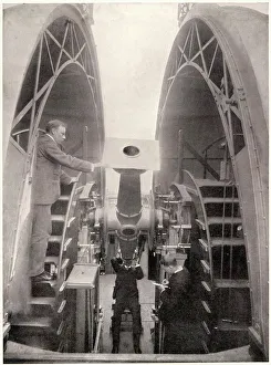
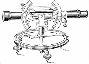
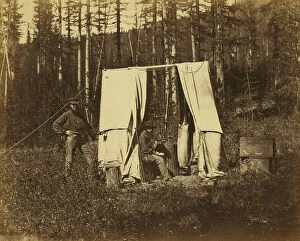
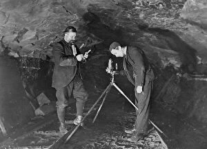
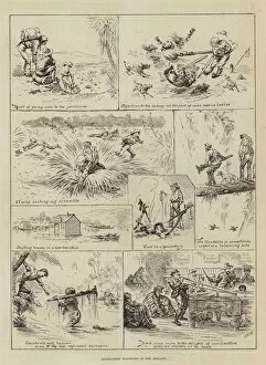
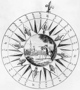
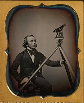
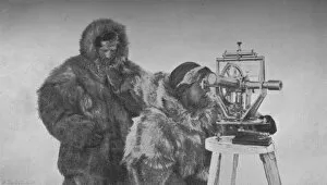
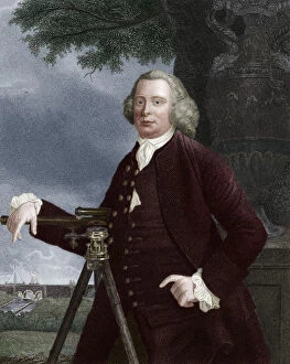
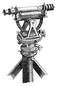
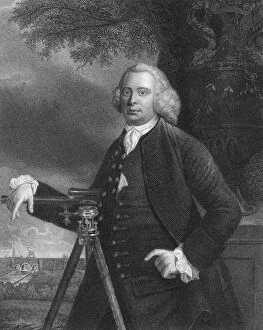
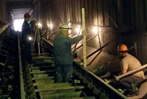
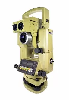
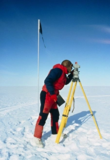
"Theodolite: A Timeless Tool for Precision and Exploration" Step back in time to the early 1900s, where coal mine surveyors relied on the trusty theodolite to navigate through treacherous underground tunnels. With its precise measurements and ability to calculate angles, this instrument ensured their safety and accuracy. Meanwhile, at Greenwich in 1911, astronomers peered through the lens of a theodolite as they meticulously observed celestial bodies. Captivated by the mysteries of space, these scientists used this remarkable device to map out constellations and unravel secrets hidden within our universe. Lieut. Evans stood proudly with his theodolite in hand, ready to embark on an adventure into uncharted territories. As he surveyed new lands, his trusty companion allowed him to accurately plot maps and establish boundaries that would shape nations. Across distant shores in New Zealand, government surveyors utilized engraved instruments like Jesse Ramsden's masterpiece - The Theodolite. These skilled individuals painstakingly measured vast landscapes with unwavering precision; their work forming a foundation for development and progress. At Cape Town's Royal Observatory, sketches captured moments of intense focus as astronomers gazed upon distant stars using their trusted tool – The Theodolite. Through meticulous observations made possible by this instrument's intricate design, they expanded humanity's understanding of our place in the cosmos. Engravings depicting compasses adorned with scenes of surveying showcased how intricately woven into history this versatile device became. From field battalions conducting surveys amidst challenging terrains to individual surveyors braving unknown landscapes armed only with their trusty tools – all owed a debt of gratitude to The Theodolite. Today, though technology has advanced exponentially since those early days, we still recognize the importance of this timeless tool. Modern versions continue aiding engineers in constructing skyscrapers that touch clouds while guiding explorers across desolate terrains. Theodolite.