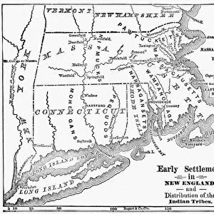
MAP: RESERVATIONS, 1892. Indian tribes, reservations and settlements in the United States

![]()
Wall Art and Photo Gifts from Granger
MAP: RESERVATIONS, 1892. Indian tribes, reservations and settlements in the United States
MAP: RESERVATIONS, 1892.
Indian tribes, reservations and settlements in the United States. Lithograph, 1939
Granger holds millions of images spanning more than 25,000 years of world history, from before the Stone Age to the dawn of the Space Age
Media ID 13636336
Bureau Of Indian Affairs Native American Reservation Tribe United States
EDITORS COMMENTS
This lithograph print titled "MAP: RESERVATIONS, 1892" takes us back to a significant period in American history. Created by the American Bureau of Indian Affairs in 1939, this sepia-toned map showcases the intricate network of Indian tribes, reservations, and settlements across the United States during the late 19th century. The detailed craftsmanship of this lithograph allows us to explore the vast territories that were designated as Native American reservations at that time. Each tribe is represented with its own distinct text label, highlighting their unique presence within these lands. The careful arrangement of names and boundaries provides a visual narrative of how indigenous communities were organized and connected across different regions. As we delve into this historical artifact from The Granger Collection's archives, it becomes evident that this map serves as both an educational tool and a testament to America's complex relationship with its native inhabitants. It prompts us to reflect on the impact of colonization and forced displacement on indigenous peoples throughout history. Through studying this lithograph print, we gain insight into how Native Americans navigated their existence within reservation boundaries while preserving their cultural heritage. It reminds us of our responsibility to honor and respect these diverse tribal nations who have shaped America's rich tapestry since time immemorial. In essence, "MAP: RESERVATIONS, 1892" invites viewers to embark on a journey through time—an exploration that encourages understanding and appreciation for the resilience and contributions of Native American communities throughout our nation's past.
MADE IN AUSTRALIA
Safe Shipping with 30 Day Money Back Guarantee
FREE PERSONALISATION*
We are proud to offer a range of customisation features including Personalised Captions, Color Filters and Picture Zoom Tools
SECURE PAYMENTS
We happily accept a wide range of payment options so you can pay for the things you need in the way that is most convenient for you
* Options may vary by product and licensing agreement. Zoomed Pictures can be adjusted in the Cart.