Home > Arts > Landscape paintings > Waterfall and river artworks > River artworks
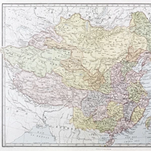
Asia Map Late 19th Century

![]()
Wall Art and Photo Gifts from Granger
Asia Map Late 19th Century
Granger holds millions of images spanning more than 25,000 years of world history, from before the Stone Age to the dawn of the Space Age
Media ID 6620063
FEATURES IN THESE COLLECTIONS
> Arts
> Landscape paintings
> Waterfall and river artworks
> River artworks
> Asia
> Related Images
> Granger Art on Demand
> Maps
> Maps and Charts
> Related Images
EDITORS COMMENTS
This print showcases an exquisite piece of history - the Asia Map from the late 19th century. A true testament to cartographic artistry, this map takes us on a visual journey through time, offering a glimpse into the intricate details and vastness of the Asian continent during that era. The rich hues and meticulous craftsmanship of this print transport us back to a period when exploration and discovery were at their peak. Every contour, river, and mountain range is delicately etched onto the paper, revealing both geographical accuracy and artistic finesse. It serves as a reminder of how maps have played an essential role in shaping our understanding of the world throughout centuries. As we delve deeper into this masterpiece, we are reminded of Asia's immense cultural diversity and historical significance. From China's majestic landscapes to India's vibrant tapestry of colors; from Japan's refined traditions to Russia's expansive territories - every corner holds its own unique story waiting to be unraveled. The Granger Collection has flawlessly preserved this remarkable artifact for us to admire today. With each glance at this photo print, we can't help but feel a sense of awe towards those intrepid explorers who ventured into unknown lands armed with little more than curiosity and determination. Whether you're an avid historian or simply captivated by the beauty within maps themselves, this stunning artwork will undoubtedly become a cherished addition to any collection. Let it inspire your imagination as you embark on your own personal voyage through time and space.
MADE IN AUSTRALIA
Safe Shipping with 30 Day Money Back Guarantee
FREE PERSONALISATION*
We are proud to offer a range of customisation features including Personalised Captions, Color Filters and Picture Zoom Tools
SECURE PAYMENTS
We happily accept a wide range of payment options so you can pay for the things you need in the way that is most convenient for you
* Options may vary by product and licensing agreement. Zoomed Pictures can be adjusted in the Cart.