Greetings Card > Animals > Mammals > Cercopithecidae > Mauritius
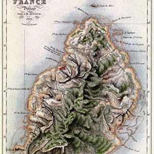
Greetings Card : Map of Mauritius, illustration from Paul et Virginie by Henri Bernardin de Saint-Pierre


![]()
Cards from Fine Art Finder
Map of Mauritius, illustration from Paul et Virginie by Henri Bernardin de Saint-Pierre
XIR180649 Map of Mauritius, illustration from Paul et Virginie by Henri Bernardin de Saint-Pierre (1737-1814) engraved by Dyonnet, 1836 (coloured engraving) by Dufour, A.H. (fl.1836) (after); Bibliotheque Nationale, Paris, France; (add.info.: location of Virginies drowning marked and where her body washed up on the beach; ); French, out of copyright
Media ID 12746106
© www.bridgemanimages.com
Ile De France Indian Ocean Maurice Ile Maurice
Greetings Card (7"x5")
Bring a touch of exotic charm to your correspondence with our Mauritius Greetings Cards from Media Storehouse. Featuring an enchanting illustration from Paul et Virginie by Henri Bernardin de Saint-Pierre, these cards showcase a beautifully detailed map of Mauritius. This captivating design, originally engraved by Dyonnet in 1836 and colorfully rendered by A.H. Dufour, is sourced from the extensive collection at Bridgeman Images through Fine Art Finder. Perfect for any occasion, these cards are a delightful way to add a personal and cultured touch to your messages.
Folded Greeting Cards (12.5x17.5 cm) have a laminate finish and are supplied with an envelope. The front and inside can be personalised with text in a selection of fonts, layouts and colours.
Greetings Cards suitable for Birthdays, Weddings, Anniversaries, Graduations, Thank You and much more
Estimated Product Size is 17.5cm x 12.5cm (6.9" x 4.9")
These are individually made so all sizes are approximate
Artwork printed orientated as per the preview above, with landscape (horizontal) or portrait (vertical) orientation to match the source image.
FEATURES IN THESE COLLECTIONS
> Fine Art Finder
> Maps (celestial & Terrestrial)
> Africa
> Mauritius
> Related Images
> Animals
> Mammals
> Cercopithecidae
> Mauritius
> Arts
> Artists
> O
> Oceanic Oceanic
> Europe
> France
> Paris
> Maps
> Europe
> France
> Paris
> Related Images
> Maps and Charts
> Related Images
> North America
> Saint Pierre and Miquelon
> Saint-Pierre
EDITORS COMMENTS
This print showcases a beautifully detailed "Map of Mauritius" from the renowned novel "Paul et Virginie" by Henri Bernardin de Saint-Pierre. Engraved by Dyonnet in 1836 and colored by Dufour, this illustration transports us to the enchanting island of Mauritius in the Indian Ocean. The map not only serves as a geographical guide but also holds significant emotional weight within the story. It marks the location where Virginie tragically drowned and where her lifeless body was discovered on the sandy shores. This poignant detail adds an extra layer of depth to this already stunning artwork. With its coastal charm and picturesque landscapes, Mauritius is brought to life through this intricate engraving. The delicate strokes capture every contour of its coastline, showcasing both its natural beauty and historical importance. As we gaze upon this print, we are transported into a world filled with tropical allure and rich cultural heritage. The vibrant colors used in the engraving evoke a sense of warmth and tranquility that perfectly encapsulate the essence of Mauritius. Whether you are an art enthusiast or simply captivated by travel, this print offers a glimpse into both history and imagination. It invites us to explore the wonders of Mauritius while reminding us of love's enduring power even amidst tragedy.
MADE IN AUSTRALIA
Safe Shipping with 30 Day Money Back Guarantee
FREE PERSONALISATION*
We are proud to offer a range of customisation features including Personalised Captions, Color Filters and Picture Zoom Tools
SECURE PAYMENTS
We happily accept a wide range of payment options so you can pay for the things you need in the way that is most convenient for you
* Options may vary by product and licensing agreement. Zoomed Pictures can be adjusted in the Cart.