Greetings Card > Arts > Artists > H > Joris Hoefnagel
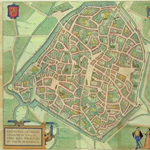
Greetings Card : Map of Granada, from Civitates Orbis Terrarum, Volume I number 4


![]()
Cards from Fine Art Finder
Map of Granada, from Civitates Orbis Terrarum, Volume I number 4
STC121047 Map of Granada, from Civitates Orbis Terrarum, Volume I number 4, by Georg Braun (1541-1622) and Frans Hogenberg (1535-90), 1565 (coloured engraving) by Hoefnagel, Joris (1542-1600) (after); Private Collection; The Stapleton Collection; Flemish, out of copyright
Media ID 22217194
© The Stapleton Collection / Bridgeman Images
Cities Of The World Ploughing Town Plan
Greetings Card (7"x5")
Add a touch of history and culture to your greetings with our exquisite Map of Granada greeting cards from Media Storehouse. This stunning design is taken from the Civitates Orbis Terrarum, Volume I number 4, created by the masterful collaboration of Georg Braun and Frans Hogenberg in 1565. The intricately detailed engraving, beautifully colored by Hoefnagel, showcases the historic city of Granada, Spain, as it appeared centuries ago. Impress your loved ones with this unique and thoughtful card that combines the beauty of fine art and the importance of history in one delightful package.
Folded Greeting Cards (12.5x17.5 cm) have a laminate finish and are supplied with an envelope. The front and inside can be personalised with text in a selection of fonts, layouts and colours.
Greetings Cards suitable for Birthdays, Weddings, Anniversaries, Graduations, Thank You and much more
Estimated Product Size is 12.5cm x 17.5cm (4.9" x 6.9")
These are individually made so all sizes are approximate
Artwork printed orientated as per the preview above, with landscape (horizontal) or portrait (vertical) orientation to match the source image.
FEATURES IN THESE COLLECTIONS
> Fine Art Finder
> Artists
> Joris (after) Hoefnagel
> Fine Art Finder
> Maps (celestial & Terrestrial)
> Arts
> Artists
> H
> Joris Hoefnagel
> Europe
> Spain
> Related Images
> Maps and Charts
> Related Images
> Maps and Charts
> Spain
> Maps and Charts
> World
EDITORS COMMENTS
This print showcases a remarkable piece of cartographic history - the Map of Granada from Civitates Orbis Terrarum. Created by Georg Braun and Frans Hogenberg in 1565, this coloured engraving offers a fascinating glimpse into the city's past. The intricate details depicted on this map transport us back to 16th-century Spain, where bustling streets and vibrant town squares come to life. The viewer is immediately drawn to the lively scene unfolding before them; people dancing, playing music, and engaging in various activities that capture the essence of Spanish culture. Amidst all the urban bustle, we also catch a glimpse of rural life as farmers diligently plow their fields with horses and oxen. This juxtaposition between city and countryside beautifully illustrates the importance of agriculture in sustaining both Granada's economy and its inhabitants' livelihoods. As we delve deeper into this historical masterpiece, it becomes evident that every stroke of Joris Hoefnagel's engraving tells a story. From majestic farmhouses dotting the landscape to meticulously planned city layouts, each element contributes to our understanding of Granada's rich heritage. This print not only serves as an exquisite decorative piece but also invites us on a journey through time. It reminds us that beneath modern skyscrapers lie centuries-old foundations built upon tradition, resilience, and cultural diversity – making Granada an enchanting destination for both historians and wanderlust-filled travelers alike.
MADE IN AUSTRALIA
Safe Shipping with 30 Day Money Back Guarantee
FREE PERSONALISATION*
We are proud to offer a range of customisation features including Personalised Captions, Color Filters and Picture Zoom Tools
SECURE PAYMENTS
We happily accept a wide range of payment options so you can pay for the things you need in the way that is most convenient for you
* Options may vary by product and licensing agreement. Zoomed Pictures can be adjusted in the Cart.