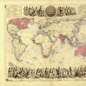
Greetings Card > Europe > United Kingdom > England > London > Museums > National Maritime Museum
Greetings Card : Chart of Nova Scotia, Bay of Fundy, Gullivers Hole to St Croix Bay, first published 10th February 1858, 1858 (technical drawing)
")

")

![]()
Cards from Fine Art Finder
Chart of Nova Scotia, Bay of Fundy, Gullivers Hole to St Croix Bay, first published 10th February 1858, 1858 (technical drawing)
7340911 Chart of Nova Scotia, Bay of Fundy, Gullivers Hole to St Croix Bay, first published 10th February 1858, 1858 (technical drawing) by Unknown Artist, (19th century); National Maritime Museum, London, UK; (add.info.: Unknown Artist, (19th century)); © National Maritime Museum, Greenwich, London
Media ID 38177642
© © National Maritime Museum, Greenwich, London / Bridgeman Images
Greetings Card (7"x5")
Send a piece of history with our range of Greetings Cards featuring this stunning technical drawing of Nova Scotia from 1858. Perfect for any occasion, these cards are sure to impress with their vintage charm and intricate detail.
Folded Greeting Cards (12.5x17.5 cm) have a laminate finish and are supplied with an envelope. The front and inside can be personalised with text in a selection of fonts, layouts and colours.
Greetings Cards suitable for Birthdays, Weddings, Anniversaries, Graduations, Thank You and much more
Estimated Product Size is 12.5cm x 17.5cm (4.9" x 6.9")
These are individually made so all sizes are approximate
Artwork printed orientated as per the preview above, with landscape (horizontal) or portrait (vertical) orientation to match the source image.
FEATURES IN THESE COLLECTIONS
> Fine Art Finder
> Artists
> Unknown Artist
> Europe
> United Kingdom
> England
> London
> Boroughs
> Greenwich
> Europe
> United Kingdom
> England
> London
> Museums
> Greenwich Heritage Centre
> Europe
> United Kingdom
> England
> London
> Museums
> National Maritime Museum
> Europe
> United Kingdom
> England
> London
> Towns
> Greenwich
> Europe
> United Kingdom
> Heritage Sites
> Maritime Greenwich
> Europe
> United Kingdom
> Maps
> Maps and Charts
> Early Maps
> North America
> Canada
> Maps
> North America
> Canada
> Related Images
EDITORS COMMENTS
This stunning technical drawing of the Chart of Nova Scotia, Bay of Fundy, Gullivers Hole to St Croix Bay, first published on February 10th, 1858, offers a fascinating glimpse into the intricate art of cartography in the 19th century. The detailed map showcases the rugged coastline and intricate waterways of Nova Scotia and the Bay of Fundy with precision and accuracy.
Created by an unknown artist from the 19th century, this historical piece is a testament to the skill and craftsmanship required to produce such intricate maps before modern technology made it easier. The black-and-white illustration captures every detail of the landscape, from rocky cliffs to winding rivers.
As you study this map closely, you can almost imagine sailing through these waters yourself, navigating past Gullivers Hole and towards St Croix Bay. It serves as both a practical tool for sailors and explorers as well as a work of art in its own right.
Displayed at the National Maritime Museum in London, UK, this technical drawing is a reminder of our enduring fascination with maps and exploration. It stands as a tribute to those who came before us, charting unknown territories with nothing but pen and paper.
MADE IN AUSTRALIA
Safe Shipping with 30 Day Money Back Guarantee
FREE PERSONALISATION*
We are proud to offer a range of customisation features including Personalised Captions, Color Filters and Picture Zoom Tools
SECURE PAYMENTS
We happily accept a wide range of payment options so you can pay for the things you need in the way that is most convenient for you
* Options may vary by product and licensing agreement. Zoomed Pictures can be adjusted in the Cart.