Greetings Card > Renaissance art
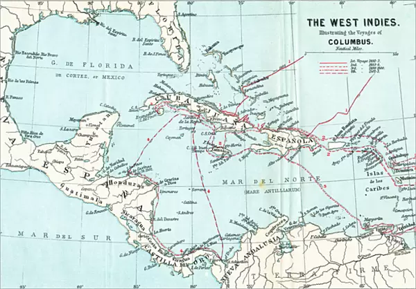
Greetings Card : Map of the West Indies illustrating the voyages of Christopher Columbus
![]()

Cards from Fine Art Finder
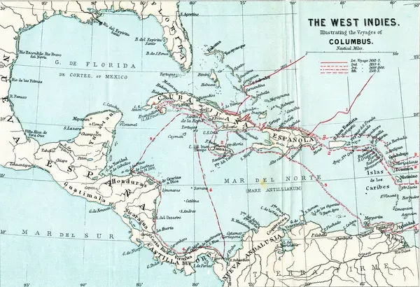
Map of the West Indies illustrating the voyages of Christopher Columbus
1772337 Map of the West Indies illustrating the voyages of Christopher Columbus, from Life of Christopher Columbus by Clements R. Markham, published 1892 (colour litho) by English School, (19th century); Photo eHilary Morgan; English, out of copyright
Media ID 22560412
© Hilary Morgan / Bridgeman Images
15th Americas Biography Chart Christopher Colon Columbus Cristobal Cristoval Discoverer Geographical Illustrating Indies Islands Mapmaking Mapping Navigation Voyages West
Greetings Card (7"x5")
Discover the rich history of exploration with our captivating selection of greeting cards from Media Storehouse. Featuring an exquisite illustration of the Map of the West Indies by Bridgeman Images from Fine Art Finder (1772337), this card brings to life the legendary voyages of Christopher Columbus as depicted in "Life of Christopher Columbus" by Clements R. Ideal for history enthusiasts or for those with a sense of adventure, this card is a thoughtful and unique way to express your sentiments. Whether for a birthday, anniversary, or just to say hello, this historical greeting card is sure to leave a lasting impression.
Folded Greeting Cards (12.5x17.5 cm) have a laminate finish and are supplied with an envelope. The front and inside can be personalised with text in a selection of fonts, layouts and colours.
Greetings Cards suitable for Birthdays, Weddings, Anniversaries, Graduations, Thank You and much more
Estimated Product Size is 12.5cm x 17.5cm (4.9" x 6.9")
These are individually made so all sizes are approximate
Artwork printed orientated as per the preview above, with landscape (horizontal) or portrait (vertical) orientation to match the source image.
FEATURES IN THESE COLLECTIONS
> Fine Art Finder
> Artists
> English School
> Fine Art Finder
> Maps (celestial & Terrestrial)
> Fine Art Finder
> Schools
> English School
> Arts
> Art Movements
> Renaissance Art
> Maps and Charts
> Related Images
> Maps and Charts
> World
EDITORS COMMENTS
This print showcases a remarkable "Map of the West Indies illustrating the voyages of Christopher Columbus". Published in 1892, this color lithograph is an invaluable piece from the Life of Christopher Columbus by Clements R. Markham. The English School's meticulous cartography skills are evident in this 19th-century masterpiece. The map takes us on a journey through time and space, unraveling the extraordinary discoveries made by Christopher Columbus during his expeditions. It vividly portrays the geographical layout of the West Indies, providing insight into the uncharted territories that were once unknown to Europeans. With its intricate details and vibrant colors, this print offers a glimpse into an era when exploration was at its peak. It serves as a testament to Columbus' audacity and determination as he ventured into uncharted waters, forever altering our understanding of world geography. As we delve deeper into this visual marvel, we can't help but appreciate how it encapsulates both artistry and historical significance. This map not only represents an important milestone in mapmaking but also highlights Columbus' pivotal role as a discoverer who opened up new horizons for future generations. Whether you're fascinated by history or simply drawn to beautiful works of art, this print is sure to captivate your imagination with its rich tapestry of discovery and exploration.
MADE IN AUSTRALIA
Safe Shipping with 30 Day Money Back Guarantee
FREE PERSONALISATION*
We are proud to offer a range of customisation features including Personalised Captions, Color Filters and Picture Zoom Tools
SECURE PAYMENTS
We happily accept a wide range of payment options so you can pay for the things you need in the way that is most convenient for you
* Options may vary by product and licensing agreement. Zoomed Pictures can be adjusted in the Cart.

