Greetings Card > Africa > Madagascar > Maps
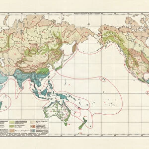
Greetings Card : Madagascar Ceylon map 1895


![]()
Cards from Fine Art Storehouse
Madagascar Ceylon map 1895
Meyers Konversations-Lexikon. Ein Nachschlagewerk des allgemeinen Wissens, 5th edition 17 volumes Bibliographisches Institut - Leipzig 1895-1897
Unleash your creativity and transform your space into a visual masterpiece!
THEPALMER
Media ID 18106735
© 2014 Roberto Adrian Photography
Greetings Card (7"x5")
Step into the past with our exquisite selection of greeting cards from Media Storehouse's Fine Art Storehouse collection. This card features a captivating image of the Madagascar Ceylon map from the 5th edition of Meyers Konversations-Lexikon, published by Bibliographisches Institut in Leipzig, 1895-1897. The intricate details of THEPALMER's map transport you back in time, making for a thoughtful and unique greeting for any occasion. Add a touch of history and elegance to your correspondence with these beautifully crafted, museum-quality cards.
Folded Greeting Cards (12.5x17.5 cm) have a laminate finish and are supplied with an envelope. The front and inside can be personalised with text in a selection of fonts, layouts and colours.
Greetings Cards suitable for Birthdays, Weddings, Anniversaries, Graduations, Thank You and much more
Estimated Product Size is 17.5cm x 12.5cm (6.9" x 4.9")
These are individually made so all sizes are approximate
Artwork printed orientated as per the preview above, with landscape (horizontal) or portrait (vertical) orientation to match the source image.
FEATURES IN THESE COLLECTIONS
> Fine Art Storehouse
> Map
> Historical Maps
> Africa
> Madagascar
> Maps
> Africa
> Madagascar
> Related Images
> Maps and Charts
> Related Images
EDITORS COMMENTS
This print showcases a historical gem, the Madagascar Ceylon map from 1895. Derived from Meyers Konversations-Lexikon, a renowned encyclopedia of general knowledge during its time, this particular edition holds immense significance. Produced in Leipzig between 1895 and 1897 by Bibliographisches Institut, it represents an era when cartography was both an art form and a means to explore the world. The map itself is a testament to the meticulous craftsmanship of the past. With intricate details and vibrant colors, it transports us back to an age when these exotic lands were shrouded in mystery. The inclusion of Madagascar and Ceylon (now known as Sri Lanka) adds further allure to this piece. As we delve into history through this photograph, we are reminded of how far humanity has come in terms of geographical understanding. It serves as a reminder that our world is ever-evolving; what was once unknown becomes familiar over time. THEPALMER's expert touch brings out the essence of this vintage masterpiece with precision and finesse. Through their lens, they capture not only the physical attributes but also evoke emotions tied to exploration and discovery. Whether you are an avid collector or simply appreciate artistry rooted in history, this print offers a glimpse into another era—a visual portal connecting us with generations past while reminding us that there is always more left for us to uncover on our own journey through life's vast landscapes.
MADE IN AUSTRALIA
Safe Shipping with 30 Day Money Back Guarantee
FREE PERSONALISATION*
We are proud to offer a range of customisation features including Personalised Captions, Color Filters and Picture Zoom Tools
SECURE PAYMENTS
We happily accept a wide range of payment options so you can pay for the things you need in the way that is most convenient for you
* Options may vary by product and licensing agreement. Zoomed Pictures can be adjusted in the Cart.