Greetings Card > Europe > France > Maps
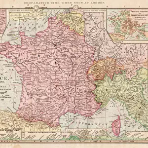
Greetings Card : Map of France 1900


![]()
Cards from Fine Art Storehouse
Map of France 1900
Meyers hand-Atlas Leipzig und Wien Verlag des Bibliographischen Instituts 1900
Unleash your creativity and transform your space into a visual masterpiece!
THEPALMER
Media ID 18106897
© 2014 Roberto Adrian Photography
Greetings Card (7"x5")
Add a touch of historical charm to your correspondence with our vintage Map of France 1900 Greetings Cards from Media Storehouse. Featuring an intricately detailed image of the map by THEPALMER from the Fine Art Storehouse, this card is taken from the renowned Meyers Hand-Atlas published by the Bibliographischen Instituts Leipzig und Wien Verlag in 1900. Perfect for anniversaries, milestone birthdays, or simply to brighten someone's day, these unique cards are a thoughtful and stylish way to express your sentiments. Each card comes with an envelope and is blank inside for your personal message.
Folded Greeting Cards (12.5x17.5 cm) have a laminate finish and are supplied with an envelope. The front and inside can be personalised with text in a selection of fonts, layouts and colours.
Greetings Cards suitable for Birthdays, Weddings, Anniversaries, Graduations, Thank You and much more
Estimated Product Size is 17.5cm x 12.5cm (6.9" x 4.9")
These are individually made so all sizes are approximate
Artwork printed orientated as per the preview above, with landscape (horizontal) or portrait (vertical) orientation to match the source image.
FEATURES IN THESE COLLECTIONS
> Fine Art Storehouse
> Map
> Historical Maps
EDITORS COMMENTS
In this print titled "Map of France 1900" we are transported back in time to the turn of the century. The intricate details and exquisite craftsmanship of this piece, sourced from Meyers hand-Atlas Leipzig und Wien Verlag des Bibliographischen Instituts in 1900, truly capture the essence of a bygone era. As our eyes wander across the map's surface, we are immersed in a world where borders were different, cities had yet to undergo modernization, and transportation networks were still evolving. The delicate lines trace rivers and mountain ranges while dotted symbols mark towns and villages that once thrived with life. The faded hues lend an air of nostalgia to the print, reminding us that history is not just about facts but also about stories waiting to be discovered. It invites us to imagine what life was like during that period - bustling markets filled with merchants trading goods, horse-drawn carriages traversing cobblestone streets, and grand châteaux dotting the countryside. "The Map of France 1900" by THEPALMER serves as both a visual delight for art enthusiasts and a historical treasure for those fascinated by cartography. Its presence on display at Fine Art Storehouse allows viewers to appreciate its beauty up close while contemplating how much has changed since it was first created over a century ago. This remarkable artwork transports us through time and space, inviting us on an exploration of France's rich past while igniting our curiosity about what lies beyond its borders.
MADE IN AUSTRALIA
Safe Shipping with 30 Day Money Back Guarantee
FREE PERSONALISATION*
We are proud to offer a range of customisation features including Personalised Captions, Color Filters and Picture Zoom Tools
SECURE PAYMENTS
We happily accept a wide range of payment options so you can pay for the things you need in the way that is most convenient for you
* Options may vary by product and licensing agreement. Zoomed Pictures can be adjusted in the Cart.