Greetings Card > North America > United States of America > New York > New York > Maps
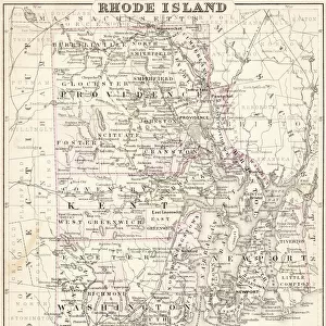
Greetings Card : Map of Rhode island 1883


![]()
Cards from Fine Art Storehouse
Map of Rhode island 1883
Encyclopedia Britannica 9th Edition New York Samuel L. Hall 1883 Vol XX
Unleash your creativity and transform your space into a visual masterpiece!
THEPALMER
Media ID 14756736
© This content is subject to copyright
Greetings Card (7"x5")
"Step back in time with our unique and captivating selection of greeting cards from Media Storehouse. This particular design features an exquisite antique map of Rhode Island, taken from the Encyclopedia Britannica 9th Edition published in New York in 1883. The intricate details of this map, sourced from THEPALMER at the Fine Art Storehouse, make for a stunning and thoughtful message for any occasion. Bring history to life with each greeting, and add a touch of vintage charm to your correspondence. Perfect for history enthusiasts, collectors, or those who appreciate the beauty of the past."
Folded Greeting Cards (12.5x17.5 cm) have a laminate finish and are supplied with an envelope. The front and inside can be personalised with text in a selection of fonts, layouts and colours.
Greetings Cards suitable for Birthdays, Weddings, Anniversaries, Graduations, Thank You and much more
Estimated Product Size is 17.5cm x 12.5cm (6.9" x 4.9")
These are individually made so all sizes are approximate
Artwork printed orientated as per the preview above, with landscape (horizontal) or portrait (vertical) orientation to match the source image.
FEATURES IN THESE COLLECTIONS
> Fine Art Storehouse
> Map
> Historical Maps
> Maps and Charts
> Related Images
> North America
> United States of America
> New York
> New York
> Maps
> North America
> United States of America
> New York
> Related Images
EDITORS COMMENTS
This print showcases a historical gem, the "Map of Rhode Island 1883" sourced from the esteemed Encyclopedia Britannica 9th Edition. Immerse yourself in a bygone era as you explore this meticulously detailed cartographic masterpiece. Crafted by Samuel L. Hall in New York during the late 19th century, this map offers a fascinating glimpse into Rhode Island's past. Every inch of this artwork is adorned with intricate lines and delicate shading, capturing the essence of an era long gone. The artist's dedication to accuracy is evident as they depict every town, river, and road with remarkable precision. This visual treasure allows us to trace the evolution of Rhode Island's landscape over time. As we delve into its depths, we discover quaint villages nestled amidst lush greenery and bustling cities brimming with life. The map invites us on a journey through history, offering insights into how communities were connected and how they flourished during that period. "The Map of Rhode Island 1883" transports us back to an age when maps were not just navigational tools but works of art themselves. It serves as a testament to human curiosity and our desire to understand our surroundings better. Whether you are an avid historian or simply appreciate fine craftsmanship, this print captures the essence of nostalgia while celebrating Rhode Island's rich heritage. Let it grace your walls and ignite conversations about days gone by – a true tribute to both artistry and history itself.
MADE IN AUSTRALIA
Safe Shipping with 30 Day Money Back Guarantee
FREE PERSONALISATION*
We are proud to offer a range of customisation features including Personalised Captions, Color Filters and Picture Zoom Tools
SECURE PAYMENTS
We happily accept a wide range of payment options so you can pay for the things you need in the way that is most convenient for you
* Options may vary by product and licensing agreement. Zoomed Pictures can be adjusted in the Cart.