Greetings Card > Arts > Artists > B > Augustus Butler
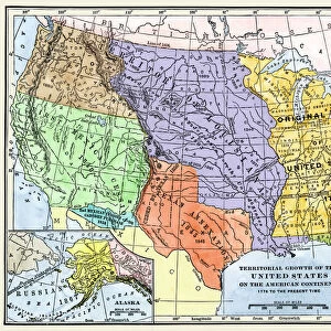
Greetings Card : Map of Texas, Louisiana and Arkansas 1881


![]()
Cards from Fine Art Storehouse
Map of Texas, Louisiana and Arkansas 1881
A System of Modern Geography designed for the use of schools and academies by Augustus Mitchell - Published by T. H. Butler / Philadelphia 1881
Unleash your creativity and transform your space into a visual masterpiece!
THEPALMER
Media ID 18357225
Greetings Card (7"x5")
Step back in time with our vintage greeting cards from Media Storehouse's Map Collection. This charming design features an 1881 map of Texas, Louisiana, and Arkansas, taken from "A System of Modern Geography" by Augustus Mitchell, published by T.H. Butler in Philadelphia. The intricate details of this antique map, showcasing the historical borders and topography of the region, make for a unique and thoughtful greeting. Perfect for history buffs, travel enthusiasts, or anyone looking to add a touch of nostalgia to their correspondence.
Folded Greeting Cards (12.5x17.5 cm) have a laminate finish and are supplied with an envelope. The front and inside can be personalised with text in a selection of fonts, layouts and colours.
Greetings Cards suitable for Birthdays, Weddings, Anniversaries, Graduations, Thank You and much more
Estimated Product Size is 12.5cm x 17.5cm (4.9" x 6.9")
These are individually made so all sizes are approximate
Artwork printed orientated as per the preview above, with landscape (horizontal) or portrait (vertical) orientation to match the source image.
FEATURES IN THESE COLLECTIONS
> Fine Art Storehouse
> Map
> Historical Maps
> Arts
> Artists
> B
> Augustus Butler
> Maps and Charts
> Related Images
EDITORS COMMENTS
This print showcases a remarkable piece of history, the "Map of Texas, Louisiana and Arkansas 1881". Created by Augustus Mitchell and published in Philadelphia in the same year, this map offers a fascinating glimpse into the geographical landscape of these southern states during that era. The intricate details on this vintage map are truly awe-inspiring. Every contour, river, and city is meticulously illustrated with precision and accuracy. It serves as a testament to Mitchell's dedication to cartography and his commitment to providing an educational resource for schools and academies. As we gaze upon this beautifully preserved print from Fine Art Storehouse, we can't help but be transported back in time. We imagine students eagerly studying this very map in classrooms long ago, tracing their fingers along its borders while absorbing knowledge about the vast territories it represents. Beyond its historical significance lies an aesthetic appeal that captivates viewers even today. The rich colors used to depict each state evoke a sense of nostalgia while highlighting the unique topographical features found within them. "The Map of Texas, Louisiana and Arkansas 1881" is not just a mere representation of land boundaries; it encapsulates an entire era's spirit through its artistry and meticulous attention to detail. This stunning print by THEPALMER allows us to appreciate both the beauty of cartography as well as our connection to past generations who relied on such maps for education and exploration purposes.
MADE IN AUSTRALIA
Safe Shipping with 30 Day Money Back Guarantee
FREE PERSONALISATION*
We are proud to offer a range of customisation features including Personalised Captions, Color Filters and Picture Zoom Tools
SECURE PAYMENTS
We happily accept a wide range of payment options so you can pay for the things you need in the way that is most convenient for you
* Options may vary by product and licensing agreement. Zoomed Pictures can be adjusted in the Cart.