Greetings Card > Arts > Artists > B > Augustus Butler
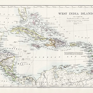
Greetings Card : Map of West Indies 1881


![]()
Cards from Fine Art Storehouse
Map of West Indies 1881
A System of Modern Geography designed for the use of schools and academies by Augustus Mitchell - Published by T. H. Butler / Philadelphia 1881
Unleash your creativity and transform your space into a visual masterpiece!
THEPALMER
Media ID 18357239
Greetings Card (7"x5")
Add a touch of historical charm to your greetings with Media Storehouse's unique range of greeting cards. This exquisite design features a vintage map of the West Indies from 1881, taken from "A System of Modern Geography" by Augustus Mitchell, published by T.H. Butler in Philadelphia. The intricate details of this antique map by THEPALMER transport you back in time, making for a thoughtful and distinctive greeting for any occasion. Impress your loved ones with this beautiful fusion of history and art.
Folded Greeting Cards (12.5x17.5 cm) have a laminate finish and are supplied with an envelope. The front and inside can be personalised with text in a selection of fonts, layouts and colours.
Greetings Cards suitable for Birthdays, Weddings, Anniversaries, Graduations, Thank You and much more
Estimated Product Size is 12.5cm x 17.5cm (4.9" x 6.9")
These are individually made so all sizes are approximate
Artwork printed orientated as per the preview above, with landscape (horizontal) or portrait (vertical) orientation to match the source image.
FEATURES IN THESE COLLECTIONS
> Fine Art Storehouse
> Map
> Historical Maps
> Arts
> Artists
> B
> Augustus Butler
> Maps and Charts
> Related Images
EDITORS COMMENTS
This print showcases a historical gem, the "Map of West Indies 1881" meticulously designed by Augustus Mitchell and published in Philadelphia back in 1881. A true testament to the artistry of cartography, this map was specifically created for educational purposes, catering to schools and academies at that time. The intricate details on this vintage map transport us back to an era when exploration and discovery were paramount. Every line, contour, and label tells a story of the rich history and cultural diversity that defines the West Indies region. From Jamaica's lush landscapes to Cuba's vibrant cities, each island is beautifully represented with precision. As we gaze upon this remarkable piece of history captured by THEPALMER from Fine Art Storehouse, we can't help but appreciate its significance as both an artistic masterpiece and a valuable educational tool. It serves as a reminder of how maps have played an essential role in shaping our understanding of geography throughout generations. Whether you are an avid collector or simply intrigued by historical artifacts, this print offers a unique opportunity to own a tangible piece of the past. Let it serve as a conversation starter or adorn your walls with its timeless charm – either way, it will undoubtedly bring joy to any admirer who appreciates the beauty found within old maps like these.
MADE IN AUSTRALIA
Safe Shipping with 30 Day Money Back Guarantee
FREE PERSONALISATION*
We are proud to offer a range of customisation features including Personalised Captions, Color Filters and Picture Zoom Tools
SECURE PAYMENTS
We happily accept a wide range of payment options so you can pay for the things you need in the way that is most convenient for you
* Options may vary by product and licensing agreement. Zoomed Pictures can be adjusted in the Cart.