Greetings Card > Arts > Photorealistic artworks > Detailed art pieces > Masterful detailing in art
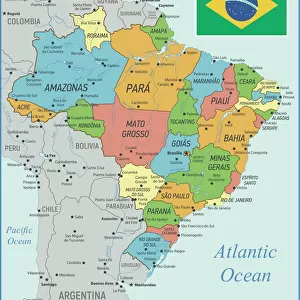
Greetings Card : Brazil Vector Map


![]()
Cards from Fine Art Storehouse
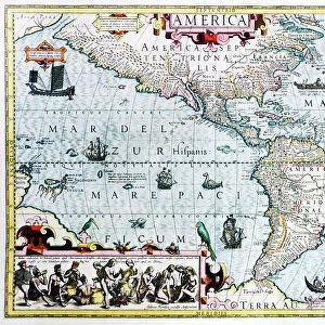
Brazil Vector Map
Ultra detailed vector map of Brazil with administrative divisions. Including main rivers and lakes. Each state is grouped separately. You can zoom in well in the vector file. Theres more detail visible than you can see in the preview window, because theres a limit of 6000 pixels. You may open the.eps-file in Photoshop at even higher resolutions. Great for super-size usage like trade fair walls. File was created on February 18, 2013. The colors in the.eps-file are ready for print (CMYK). Included files: EPS (v8) and Hi-Res JPG (6000aua6000 px)
Unleash your creativity and transform your space into a visual masterpiece!
Media ID 14833443
Greetings Card (7"x5")
Bring a touch of South American charm to your correspondence with our Media Storehouse range of greeting cards. Featuring an exquisitely detailed vector map of Brazil, these cards showcase the administrative divisions, major rivers, and lakes of this vibrant country. Each state is meticulously grouped and labeled, allowing you to explore the intricacies of Brazil's geography up close. Impress your loved ones with this unique and visually stunning design, perfect for any occasion.
Folded Greeting Cards (12.5x17.5 cm) have a laminate finish and are supplied with an envelope. The front and inside can be personalised with text in a selection of fonts, layouts and colours.
Greetings Cards suitable for Birthdays, Weddings, Anniversaries, Graduations, Thank You and much more
Estimated Product Size is 17.5cm x 12.5cm (6.9" x 4.9")
These are individually made so all sizes are approximate
Artwork printed orientated as per the preview above, with landscape (horizontal) or portrait (vertical) orientation to match the source image.
FEATURES IN THESE COLLECTIONS
> Fine Art Storehouse
> Map
> Map Illustrations
> Animals
> Fishes
> G
> Grouper
> Arts
> Landscape paintings
> Waterfall and river artworks
> River artworks
> Arts
> Photorealistic artworks
> Detailed art pieces
> Masterful detailing in art
> Maps and Charts
> Related Images
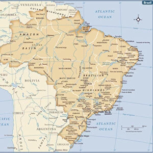
> South America
> Brazil
> Maps
> South America
> Brazil
> Related Images
EDITORS COMMENTS
This stunning print features an ultra-detailed vector map of Brazil, showcasing its administrative divisions, main rivers, and lakes. Each state is thoughtfully grouped separately, allowing for easy navigation and exploration. The level of detail in this map is truly remarkable - you can zoom in well within the vector file to uncover even more hidden gems. The preview window only offers a glimpse of the intricate beauty captured in this print due to its limit of 6000 pixels. However, if you open the . eps-file in Photoshop or similar software at higher resolutions, you'll be able to appreciate every minute detail with astonishing clarity. Designed with super-size usage in mind, this map is perfect for trade fair walls or any space that demands attention and grandeur. Created on February 18,2013, it has stood the test of time as a timeless piece of art. Printed using CMYK colors ready for high-quality printing purposes ensures that every hue and shade are accurately represented when brought to life on paper. Included files such as EPS (v8) and Hi-Res JPG (6000x6000 px) provide flexibility for various applications.
MADE IN AUSTRALIA
Safe Shipping with 30 Day Money Back Guarantee
FREE PERSONALISATION*
We are proud to offer a range of customisation features including Personalised Captions, Color Filters and Picture Zoom Tools
SECURE PAYMENTS
We happily accept a wide range of payment options so you can pay for the things you need in the way that is most convenient for you
* Options may vary by product and licensing agreement. Zoomed Pictures can be adjusted in the Cart.