Greetings Card > Maps and Charts > Americas
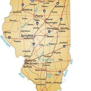
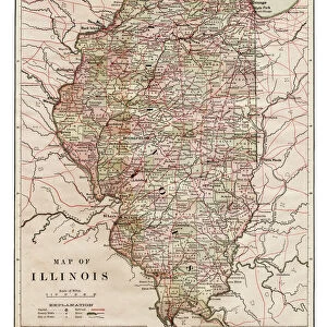
Greetings Card : Map of Illinois 1889


![]()
Cards from Fine Art Storehouse
Map of Illinois 1889
Indiana Educational Series The Complete Geography - Indianapolis 1889
Unleash your creativity and transform your space into a visual masterpiece!
THEPALMER
Media ID 14756294
© This content is subject to copyright
Chicago Illinois North America United States Peoria Rockford
Greetings Card (7"x5")
"Add a touch of history to your greetings with Media Storehouse's Indiana Educational Series Greeting Cards. This charming design features an antique map of Illinois from 1889, titled "Map of Illinois" by THEPALMER from the Fine Art Storehouse. This beautifully detailed map transports you back in time, making it a perfect card for history lovers, educators, or anyone looking to add a unique touch to their correspondence. Impress your recipients with this vintage treasure, now available as a greeting card. Send a piece of the past with every message."
Folded Greeting Cards (12.5x17.5 cm) have a laminate finish and are supplied with an envelope. The front and inside can be personalised with text in a selection of fonts, layouts and colours.
Greetings Cards suitable for Birthdays, Weddings, Anniversaries, Graduations, Thank You and much more
Estimated Product Size is 17.5cm x 12.5cm (6.9" x 4.9")
These are individually made so all sizes are approximate
Artwork printed orientated as per the preview above, with landscape (horizontal) or portrait (vertical) orientation to match the source image.
FEATURES IN THESE COLLECTIONS
> Fine Art Storehouse
> Map
> Historical Maps
> Fine Art Storehouse
> Map
> USA Maps
> Maps and Charts
> Related Images
> North America
> Related Images
> North America
> United States of America
> Illinois
> Chicago
> North America
> United States of America
> Illinois
> Peoria
> North America
> United States of America
> Illinois
> Related Images
> North America
> United States of America
> Illinois
> Rockford
> North America
> United States of America
> Indiana
> Indianapolis
> North America
> United States of America
> Indiana
> Related Images
> North America
> United States of America
> Maps
EDITORS COMMENTS
This print titled "Map of Illinois 1889" takes us on a journey back in time to the late 19th century. A part of the Indiana Educational Series, The Complete Geography - Indianapolis 1889, this vintage map showcases the intricate details and artistry that went into cartography during that era. The image transports us to an era when maps were meticulously hand-drawn and illustrated with utmost precision. Every city, town, river, and road is intricately marked, allowing us to explore the state's geography with awe-inspiring accuracy. From bustling urban centers like Chicago and Peoria to charming towns like Naperville and Rockford, this map provides a comprehensive view of Illinois' diverse landscape. As we gaze upon this piece from THEPALMER collection at Fine Art Storehouse, we can't help but appreciate its historical significance. It serves as a reminder of how far our understanding of geography has evolved over time while also highlighting the beauty inherent in these early representations. Whether you're an avid history buff or simply intrigued by cartographic artistry, this print offers a unique glimpse into Illinois' past. Hang it proudly on your wall or gift it to someone who appreciates both history and aesthetics; either way, it will undoubtedly spark conversations about our ever-changing world.
MADE IN AUSTRALIA
Safe Shipping with 30 Day Money Back Guarantee
FREE PERSONALISATION*
We are proud to offer a range of customisation features including Personalised Captions, Color Filters and Picture Zoom Tools
SECURE PAYMENTS
We happily accept a wide range of payment options so you can pay for the things you need in the way that is most convenient for you
* Options may vary by product and licensing agreement. Zoomed Pictures can be adjusted in the Cart.