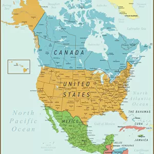
Greetings Card : MAP: UNITED STATES. British poster of a map of the United States. Lithograph, c1945


![]()
Cards from Granger
MAP: UNITED STATES. British poster of a map of the United States. Lithograph, c1945
MAP: UNITED STATES.
British poster of a map of the United States. Lithograph, c1945
Granger holds millions of images spanning more than 25,000 years of world history, from before the Stone Age to the dawn of the Space Age
Media ID 13637394
1940s 1945 British Flag Poster State United States
Greetings Card (7"x5")
Travel back in time with our vintage-inspired greeting cards from the Media Storehouse collection. This design features a captivating lithograph of a map of the United States, originally created by Granger in New York City during the 1940s. Add a touch of history and nostalgia to your correspondence with this beautifully detailed and authentic reproduction. Perfect for any occasion, our greeting cards are a thoughtful and unique way to connect with friends and loved ones.
Folded Greeting Cards (12.5x17.5 cm) have a laminate finish and are supplied with an envelope. The front and inside can be personalised with text in a selection of fonts, layouts and colours.
Greetings Cards suitable for Birthdays, Weddings, Anniversaries, Graduations, Thank You and much more
Estimated Image Size (if not cropped) is 12.5cm x 17cm (4.9" x 6.7")
Estimated Product Size is 12.5cm x 17.5cm (4.9" x 6.9")
These are individually made so all sizes are approximate
Artwork printed orientated as per the preview above, with portrait (vertical) orientation to match the source image.
EDITORS COMMENTS
This lithograph from the 1940s showcases a British poster of a map of the United States. The intricate details and vibrant colors bring this historical piece to life, offering a unique perspective on American geography during that era. The lithograph, created around 1945, exudes an air of nostalgia as it captures the essence of mid-century America. The focal point of this print is undoubtedly the beautifully rendered map itself. Every state is meticulously outlined and labeled with clear text, allowing viewers to explore the vastness and diversity of the United States in one glance. The iconic American flag proudly adorns the top left corner, symbolizing unity and patriotism. As we delve into this artwork, we are transported back in time to witness how our country was perceived by our British allies during World War II. This collaboration between nations serves as a reminder that even amidst conflict, there can be appreciation for each other's cultures and histories. Granger Art on Demand has masterfully preserved this remarkable piece from their extensive collection. By making it available for all to enjoy today, they have ensured that its beauty and significance will continue to inspire generations to come.
MADE IN AUSTRALIA
Safe Shipping with 30 Day Money Back Guarantee
FREE PERSONALISATION*
We are proud to offer a range of customisation features including Personalised Captions, Color Filters and Picture Zoom Tools
SECURE PAYMENTS
We happily accept a wide range of payment options so you can pay for the things you need in the way that is most convenient for you
* Options may vary by product and licensing agreement. Zoomed Pictures can be adjusted in the Cart.