Greetings Card > Arts > Landscape paintings > Waterfall and river artworks > River artworks
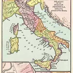
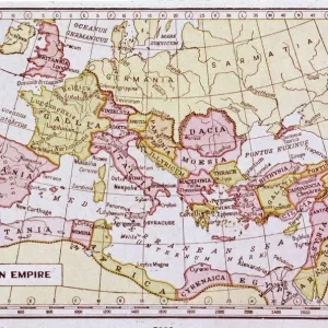
Greetings Card : AUSTRIAN EMPIRE MAP, 1795. Map of Prussia and the Austrian Empire as they appeared in the year 1795


![]()
Cards from Granger
AUSTRIAN EMPIRE MAP, 1795. Map of Prussia and the Austrian Empire as they appeared in the year 1795
Granger holds millions of images spanning more than 25,000 years of world history, from before the Stone Age to the dawn of the Space Age
Media ID 6622527
1795 Austria Austrian Empire Prussia
Greetings Card (7"x5")
"Discover history through the lens of beautiful art with our Austrian Empire Map Greeting Cards from Media Storehouse. Featuring an exquisite image of "Austrian Empire Map, 1795. Map of Prussia and the Austrian Empire as they appeared in the year 1795" by The Granger Collection from Granger Art on Demand, these cards transport you back in time. Ideal for history enthusiasts or as a unique and thoughtful gift, each card comes blank inside for your personal message. Let the intricate details of this historical map ignite curiosity and inspire your correspondence."
Folded Greeting Cards (12.5x17.5 cm) have a laminate finish and are supplied with an envelope. The front and inside can be personalised with text in a selection of fonts, layouts and colours.
Greetings Cards suitable for Birthdays, Weddings, Anniversaries, Graduations, Thank You and much more
Estimated Product Size is 12.5cm x 17.5cm (4.9" x 6.9")
These are individually made so all sizes are approximate
Artwork printed orientated as per the preview above, with landscape (horizontal) or portrait (vertical) orientation to match the source image.
FEATURES IN THESE COLLECTIONS
> Granger Art on Demand
> Maps
> Arts
> Landscape paintings
> Waterfall and river artworks
> River artworks
> Europe
> Austria
> Related Images
> Maps and Charts
> Related Images
EDITORS COMMENTS
This print showcases an exquisite map of the Austrian Empire and Prussia as they appeared in the year 1795. A true historical gem, this meticulously crafted piece takes us back to a time when empires reigned supreme and borders were defined by mighty rivers. The map beautifully illustrates the vast expanse of the Austrian Empire, stretching across Central Europe with its intricate network of territories and provinces. From Vienna to Budapest, from Bohemia to Transylvania, every corner is intricately detailed, giving us a glimpse into the immense power and influence that Austria once held. Adjacent to the Austrian Empire lies Prussia, another formidable force on the European stage during this era. The boundaries between these two great powers are clearly delineated on this map, showcasing their complex relationship and occasional conflicts throughout history. As we explore this historic artifact further, our eyes are drawn to the majestic rivers that meander through these lands - lifelines that have shaped civilizations for centuries. These waterways not only served as vital trade routes but also acted as natural barriers defining political boundaries. With its rich colors and precise cartographic details, this print from Granger Art on Demand transports us back in time. It serves as a reminder of how geography has played a pivotal role in shaping nations and empires throughout history.
MADE IN AUSTRALIA
Safe Shipping with 30 Day Money Back Guarantee
FREE PERSONALISATION*
We are proud to offer a range of customisation features including Personalised Captions, Color Filters and Picture Zoom Tools
SECURE PAYMENTS
We happily accept a wide range of payment options so you can pay for the things you need in the way that is most convenient for you
* Options may vary by product and licensing agreement. Zoomed Pictures can be adjusted in the Cart.