Greetings Card > Europe > France > Maps
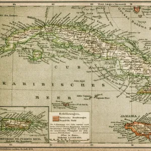
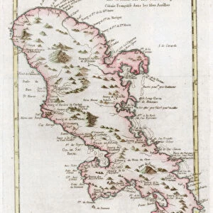
Greetings Card : CARIBBEAN MAP. A map of the Caribbean islands: woodcut, French, c. 1688


![]()
Cards from Granger
CARIBBEAN MAP. A map of the Caribbean islands: woodcut, French, c. 1688
Granger holds millions of images spanning more than 25,000 years of world history, from before the Stone Age to the dawn of the Space Age
Media ID 7514139
1688 Caribbean Island New World West Indian Wood Cut
Greetings Card (7"x5")
Introducing the captivating collection of Caribbean-themed greeting cards from Media Storehouse. Each card features an exquisite vintage map of the Caribbean islands, taken from the archives of The Granger Collection. Dating back to 1688, this French woodcut map transports you back in time, evoking the rich history and allure of the Caribbean. Whether you're sending a birthday greeting, a heartfelt thank you, or a thoughtful note to a friend, our Caribbean map greeting cards are the perfect way to add a touch of old-world charm and adventure to your correspondence. Delight in the intricate details and antique beauty of this timeless map, as you connect with friends and loved ones near and far.
Folded Greeting Cards (12.5x17.5 cm) have a laminate finish and are supplied with an envelope. The front and inside can be personalised with text in a selection of fonts, layouts and colours.
Greetings Cards suitable for Birthdays, Weddings, Anniversaries, Graduations, Thank You and much more
Estimated Product Size is 17.5cm x 12.5cm (6.9" x 4.9")
These are individually made so all sizes are approximate
Artwork printed orientated as per the preview above, with landscape (horizontal) or portrait (vertical) orientation to match the source image.
FEATURES IN THESE COLLECTIONS
> Granger Art on Demand
> Maps
> Maps and Charts
> Related Images
> Maps and Charts
> World
EDITORS COMMENTS
This print showcases a remarkable piece of history - a woodcut map of the Caribbean islands, crafted by French artisans around 1688. The intricate details and delicate engravings on this map transport us back to an era when exploration and colonization were shaping the New World. The map itself is a testament to the skill and artistry of its creators. Every island in the Caribbean archipelago is meticulously depicted, with their unique shapes and sizes accurately portrayed. The French influence is evident in the elegant design elements that adorn the edges of the map, adding a touch of sophistication to this historical artifact. As we gaze upon this vintage treasure, we are reminded of the rich cultural tapestry that defines these islands. From Cuba to Barbados, each landmass represented on this map has its own distinct identity and story waiting to be discovered. Beyond its aesthetic appeal, this woodcut serves as a window into our past. It offers valuable insights into how Europeans perceived and navigated through these uncharted waters centuries ago. It reminds us of the bravery and ambition that drove explorers like Christopher Columbus to venture into unknown territories. In acquiring this print from Granger Art on Demand, we not only bring home a beautiful piece for our collection but also pay homage to those who paved the way for our understanding of geography and history in one corner of our vast world - The Caribbean Islands.
MADE IN AUSTRALIA
Safe Shipping with 30 Day Money Back Guarantee
FREE PERSONALISATION*
We are proud to offer a range of customisation features including Personalised Captions, Color Filters and Picture Zoom Tools
SECURE PAYMENTS
We happily accept a wide range of payment options so you can pay for the things you need in the way that is most convenient for you
* Options may vary by product and licensing agreement. Zoomed Pictures can be adjusted in the Cart.