Greetings Card > Arts > Artists > P > Antonio Pigafetta
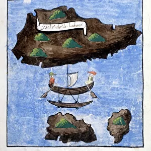
Greetings Card : STRAITS OF MAGELLAN. Antonio Pigafettas map of the Straits of Magellan showing


![]()
Cards from Granger
STRAITS OF MAGELLAN. Antonio Pigafettas map of the Straits of Magellan showing
STRAITS OF MAGELLAN.
Antonio Pigafettas map of the Straits of Magellan showing north at the bottom. Woodcut from Carlo Amorettis Premier Autour du Monde par Pigafetta, 1801
Granger holds millions of images spanning more than 25,000 years of world history, from before the Stone Age to the dawn of the Space Age
Media ID 12321036
Age Of Exploration Antoni Carlo Ferdinand Magellan Amoretti Magellan Strait Pigafetta
Greetings Card (7"x5")
Discover the rich history of exploration with our exquisite range of greeting cards from Media Storehouse. Featuring the iconic "Straits of Magellan" map by Antonio Pigafetta, these cards transport you back in time. Dating from 1401-1668, Pigafetta's detailed woodcut illustration, as seen in Carlo Amoretti's Premier Autour du Monde par Pigafetta (1801), showcases the Straits of Magellan with the north at the bottom. Ideal for history enthusiasts, these cards are perfect for sending a thoughtful message to loved ones or colleagues. Add a touch of adventure to your correspondence with our beautifully designed, historical greeting cards.
Folded Greeting Cards (12.5x17.5 cm) have a laminate finish and are supplied with an envelope. The front and inside can be personalised with text in a selection of fonts, layouts and colours.
Greetings Cards suitable for Birthdays, Weddings, Anniversaries, Graduations, Thank You and much more
Estimated Product Size is 17.5cm x 12.5cm (6.9" x 4.9")
These are individually made so all sizes are approximate
Artwork printed orientated as per the preview above, with landscape (horizontal) or portrait (vertical) orientation to match the source image.
FEATURES IN THESE COLLECTIONS
> Granger Art on Demand
> Maps
> Arts
> Artists
> P
> Antonio Pigafetta
> Maps and Charts
> Early Maps
> Maps and Charts
> Italy
> Maps and Charts
> Related Images
EDITORS COMMENTS
This print showcases Antonio Pigafetta's map of the Straits of Magellan, a significant historical artifact from the 16th century Age of Exploration. The woodcut, created by Carlo Amoretti for Premier Autour du Monde par Pigafetta in 1801, depicts the straits with an intriguing twist - north is shown at the bottom. The Straits of Magellan hold immense importance as they served as a crucial passage for Ferdinand Magellan's expedition to circumnavigate the globe. This Italian explorer and scholar meticulously documented his journey, and Pigafetta's map became one of his most renowned works. The intricate details on this woodcut beautifully capture the essence of early cartography during that era. It transports us back in time when intrepid explorers embarked on perilous voyages across uncharted territories. Amidst swirling rivers and mysterious landscapes depicted in this artwork, we can't help but marvel at how far humanity has come since then. This image serves as a reminder not only of our thirst for knowledge but also our ability to push boundaries and explore new horizons. As we gaze upon this remarkable piece, let us appreciate its historical significance and pay homage to those brave souls who paved the way for future generations' discoveries.
MADE IN AUSTRALIA
Safe Shipping with 30 Day Money Back Guarantee
FREE PERSONALISATION*
We are proud to offer a range of customisation features including Personalised Captions, Color Filters and Picture Zoom Tools
FREE COLORIZATION SERVICE
You can choose advanced AI Colorization for this picture at no extra charge!
SECURE PAYMENTS
We happily accept a wide range of payment options so you can pay for the things you need in the way that is most convenient for you
* Options may vary by product and licensing agreement. Zoomed Pictures can be adjusted in the Cart.