Greetings Card > Arts > Art Movements > Baroque
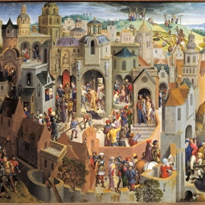
Greetings Card : Plan of the City of Rome. Part 12 with the Southwestern Border of the City


![]()
Cards from Heritage Images
Plan of the City of Rome. Part 12 with the Southwestern Border of the City
Plan of the City of Rome. Part 12 with the Southwestern Border of the City and a Large Cartouche with Signature by Tempesta. 1645. Symbols for the boroughs of Rome are identified: Ripa; Trastevere; Trevi; Campitello; Parione; Pignia; Campo di Marzo; Sant Angelo and Borgo
Heritage Images features heritage image collections
Media ID 20566129
© Heritage Art/Heritage Images
Antonio Antonio Tempesta Cartouche Environs Giovanni Domenico De Giovanni Domenico De Rossi Outskirts Plan Rome Lazio Italy Rossi Rossi Giovanni Domenico De Spear Symbol Tempesta Tempesta Antonio
Greetings Card (7"x5")
Step back in time with our exquisite selection of greeting cards from Media Storehouse. Featuring the intricately detailed Plan of the City of Rome, Part 12, by renowned artist Antonio Tempesta from Heritage Images. Dated 1645, this stunning representation of the ancient city's southwestern border showcases Tempesta's mastery of architectural and topographical depiction. Add a touch of history and artistry to your correspondence with this elegant and thoughtful card choice.
Folded Greeting Cards (12.5x17.5 cm) have a laminate finish and are supplied with an envelope. The front and inside can be personalised with text in a selection of fonts, layouts and colours.
Greetings Cards suitable for Birthdays, Weddings, Anniversaries, Graduations, Thank You and much more
Estimated Product Size is 17.5cm x 12.5cm (6.9" x 4.9")
These are individually made so all sizes are approximate
Artwork printed orientated as per the preview above, with landscape (horizontal) or portrait (vertical) orientation to match the source image.
FEATURES IN THESE COLLECTIONS
> Arts
> Art Movements
> Baroque
> Arts
> Artists
> R
> Domenico de' Rossi
> Arts
> Artists
> T
> Antonio Tempesta
> Europe
> Italy
> Lazio
> Related Images
> Europe
> Italy
> Lazio
> Rome
> Europe
> Italy
> Related Images
> Maps and Charts
> Italy
> Maps and Charts
> Related Images
EDITORS COMMENTS
This print captures the intricate "Plan of the City of Rome. Part 12 with the Southwestern Border of the City" created by Antonio Tempesta in 1645. The detailed engraving showcases a map of Rome, highlighting its various boroughs such as Ripa, Trastevere, Trevi, Campitello, Parione, Pignia, Campo di Marzo, Sant Angelo and Borgo. In this baroque era artwork, Tempesta's skillful etching brings to life the city's outskirts and surrounding farmlands. A large cartouche with his signature adds an artistic touch to this historical piece. Sitting amidst this grand depiction is a lone figure holding a spear symbolizing war and warfare. The photograph provides us with a glimpse into Italy's rich heritage as it portrays one person immersed in the vastness of Rome's metropolitan area. The use of black and white enhances the sense of timelessness associated with this 17th-century masterpiece. Displayed at The Metropolitan Museum of Art (The Met), this print serves as a valuable resource for those interested in studying or appreciating Italian history and culture. It offers viewers an opportunity to explore not only the physical layout but also conceptualize how society functioned during that period. Antonio Tempesta's work continues to be celebrated for its attention to detail and contribution to cartography. This image invites us on a journey through time while reminding us of Rome's enduring significance as both a
MADE IN AUSTRALIA
Safe Shipping with 30 Day Money Back Guarantee
FREE PERSONALISATION*
We are proud to offer a range of customisation features including Personalised Captions, Color Filters and Picture Zoom Tools
SECURE PAYMENTS
We happily accept a wide range of payment options so you can pay for the things you need in the way that is most convenient for you
* Options may vary by product and licensing agreement. Zoomed Pictures can be adjusted in the Cart.