Greetings Card > Europe > United Kingdom > Scotland > Fife > Falkland
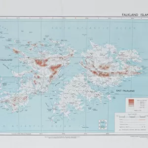
Greetings Card : Falkland Islands Royal Engineer briefing map, 1982


![]()
Cards from Mary Evans Picture Library
Falkland Islands Royal Engineer briefing map, 1982
Falkland Islands Royal Engineer briefing map, 1982 (c); with typescript annotations relating to the condition and passibility of airfields, roads and tracks by tracked and wheeled vehicles. From papers relating to the South Atlantic (Falklands War) (1982), collected by 24057159 WO2 David Langham, 81 Ordnance Company, Royal Army Ordnance Corps. Date: circa 1982
Mary Evans Picture Library makes available wonderful images created for people to enjoy over the centuries
Media ID 14404020
© The National Army Museum / Mary Evans Picture Library
1982 Airfields Annotations Atlantic Briefing Collected Condition Engineer Falkland Falklands Langham Papers Relating Roads Tracked Tracks Vehicles Wheeled Typescript
Greetings Card (7"x5")
Introducing the latest addition to our Media Storehouse Greetings Cards collection: a unique and intriguing design featuring a historic Falkland Islands Royal Engineer briefing map from 1982. This captivating card showcases an authentic, copyrighted image from Mary Evans Prints Online, with meticulous typescript annotations detailing the condition and accessibility of airfields, roads, and tracks for both tracked and wheeled vehicles. Surprise and delight your loved ones with a piece of history that's sure to spark conversation and curiosity. Each card comes blank for your personal message, making it an ideal choice for any special occasion.
Folded Greeting Cards (12.5x17.5 cm) have a laminate finish and are supplied with an envelope. The front and inside can be personalised with text in a selection of fonts, layouts and colours.
Greetings Cards suitable for Birthdays, Weddings, Anniversaries, Graduations, Thank You and much more
Estimated Product Size is 12.5cm x 17.5cm (4.9" x 6.9")
These are individually made so all sizes are approximate
Artwork printed orientated as per the preview above, with landscape (horizontal) orientation to match the source image.
FEATURES IN THESE COLLECTIONS
> Arts
> Artists
> E
> David Evans
> Europe
> United Kingdom
> Scotland
> Fife
> Falkland
> Maps and Charts
> Popular Maps
> Maps and Charts
> Related Images
> South America
> Falkland Islands
> Maps
> South America
> Falkland Islands
> Related Images
EDITORS COMMENTS
This fascinating print captures a piece of history from the Falklands War in 1982. The image shows a Falkland Islands Royal Engineer briefing map, complete with typescript annotations detailing the condition and passibility of airfields, roads, and tracks for both tracked and wheeled vehicles. This valuable document was collected by WO2 David Langham of the 81 Ordnance Company, Royal Army Ordnance Corps.
The map provides crucial information for military operations during this conflict in the South Atlantic. It offers insights into strategic planning and logistics, highlighting key routes for troops and supplies to navigate through the rugged terrain of the Falkland Islands.
As we examine this artifact, we are transported back in time to a period of intense geopolitical tension and military action. The meticulous detail on the map speaks to the dedication and expertise of those involved in its creation.
Overall, this print serves as a reminder of the sacrifices made by soldiers like WO2 David Langham during times of war. It is a testament to their bravery and commitment to serving their country under challenging circumstances.
MADE IN AUSTRALIA
Safe Shipping with 30 Day Money Back Guarantee
FREE PERSONALISATION*
We are proud to offer a range of customisation features including Personalised Captions, Color Filters and Picture Zoom Tools
SECURE PAYMENTS
We happily accept a wide range of payment options so you can pay for the things you need in the way that is most convenient for you
* Options may vary by product and licensing agreement. Zoomed Pictures can be adjusted in the Cart.