Greetings Card > Asia > Sri Lanka > Maps
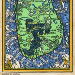
Greetings Card : Map / Asia / Sri Lanka 1719


![]()
Cards from Mary Evans Picture Library
Map / Asia / Sri Lanka 1719
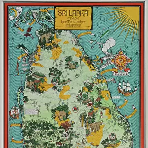
ISLE DE CEYLAN and southern India
Mary Evans Picture Library makes available wonderful images created for people to enjoy over the centuries
Media ID 576105
© Mary Evans Picture Library 2015 - https://copyrighthub.org/s0/hub1/creation/maryevans/MaryEvansPictureID/10014258
Greetings Card (7"x5")
Introducing the exquisite range of greeting cards from Media Storehouse, featuring the captivating image "Map / Asia / Sri Lanka 1719" by Mary Evans Picture Library from Mary Evans Prints Online. This vintage map transports you back in time, showcasing the intricate details of the Indian subcontinent as it appeared in 1719, with a focus on the beautiful island nation of Sri Lanka. Add a touch of history and culture to your correspondence with these stunning greeting cards, perfect for any occasion. Let the explorer in you delight in the intricacies of this fascinating map, while sharing your warmest wishes with loved ones.
Folded Greeting Cards (12.5x17.5 cm) have a laminate finish and are supplied with an envelope. The front and inside can be personalised with text in a selection of fonts, layouts and colours.
Greetings Cards suitable for Birthdays, Weddings, Anniversaries, Graduations, Thank You and much more
Estimated Product Size is 17.5cm x 12.5cm (6.9" x 4.9")
These are individually made so all sizes are approximate
Artwork printed orientated as per the preview above, with landscape (horizontal) or portrait (vertical) orientation to match the source image.
FEATURES IN THESE COLLECTIONS
> Asia
> India
> Related Images
> Asia
> Related Images
> Asia
> Sri Lanka
> Related Images
> Maps and Charts
> Early Maps
> Maps and Charts
> India
> Maps and Charts
> Related Images
EDITORS COMMENTS
This stunning historical map print from Mary Evans Picture Library showcases the intricate details of Asia and specifically Sri Lanka in 1719. The map, titled "ISLE DE CEYLAN and southern India," provides a fascinating glimpse into the geography and history of this region during that time period.
The vibrant colors and elaborate illustrations on the map bring to life the ancient landmarks, rivers, and coastlines of Sri Lanka and southern India. It is evident that great care was taken in creating this cartographic masterpiece, as every detail is meticulously rendered with precision.
As you study this map, you can't help but be transported back in time to an era when exploration and discovery were at their peak. The names of cities, regions, and bodies of water are written in elegant script, adding to the overall charm of the piece.
Whether you're a history buff or simply appreciate fine artistry, this print is sure to captivate your imagination. Display it proudly in your home or office as a conversation starter or gift it to a fellow enthusiast who shares your passion for maps and historical artifacts.
In owning this exquisite piece from Mary Evans Prints Online, you not only acquire a beautiful work of art but also a tangible connection to the past that will continue to inspire curiosity for generations to come.
MADE IN AUSTRALIA
Safe Shipping with 30 Day Money Back Guarantee
FREE PERSONALISATION*
We are proud to offer a range of customisation features including Personalised Captions, Color Filters and Picture Zoom Tools
SECURE PAYMENTS
We happily accept a wide range of payment options so you can pay for the things you need in the way that is most convenient for you
* Options may vary by product and licensing agreement. Zoomed Pictures can be adjusted in the Cart.