Greetings Card > Europe > France > Canton > Allier
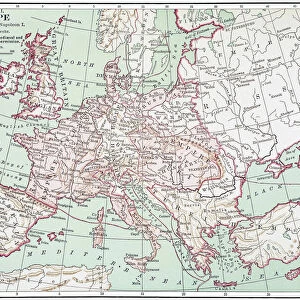
Greetings Card : Map, Britain -- Spearhead of Attack, WW2


![]()
Cards from Mary Evans Picture Library
Map, Britain -- Spearhead of Attack, WW2
Map, Britain -- Spearhead of Attack, WW2. Date: 1940s
Mary Evans Picture Library makes available wonderful images created for people to enjoy over the centuries
Media ID 14146038
© Mary Evans Picture Library/Onslow Auctions Limited
Allied Allies Attack Bombing Bombs Defence Effort Isles Manufacture Spearhead
Greetings Card (7"x5")
Introducing our latest addition to the Media Storehouse collection of greeting cards: "Map, Britain -- Spearhead of Attack, WW2." This powerful and evocative design takes you back in time with a vintage map of Britain from the 1940s, featuring the ominous title "Spearhead of Attack, WW2." The intricate details of the map, combined with the stark and bold typography, create a captivating image that is perfect for expressing sentiments of courage, resilience, and historical significance. This unique greeting card, sourced from the extensive archive of Mary Evans Prints Online, is an inspiring and thoughtful choice for any occasion. Whether you're sending a message of support, commemorating an anniversary, or simply wanting to evoke a sense of nostalgia, this card is sure to make an impact. Order now and let the history and emotion of this design speak for itself.
Folded Greeting Cards (12.5x17.5 cm) have a laminate finish and are supplied with an envelope. The front and inside can be personalised with text in a selection of fonts, layouts and colours.
Greetings Cards suitable for Birthdays, Weddings, Anniversaries, Graduations, Thank You and much more
Estimated Product Size is 12.5cm x 17.5cm (4.9" x 6.9")
These are individually made so all sizes are approximate
Artwork printed orientated as per the preview above, with landscape (horizontal) or portrait (vertical) orientation to match the source image.
FEATURES IN THESE COLLECTIONS
> Animals
> Mammals
> Muridae
> Fortior
> Europe
> France
> Canton
> Allier
> Europe
> Related Images
> Europe
> Republic of Ireland
> Maps
> Europe
> United Kingdom
> Maps
> Historic
> World War I and II
> World War II
> Maps and Charts
> Early Maps
EDITORS COMMENTS
This evocative map print, titled "Map, Britain -- Spearhead of Attack, WW2," transports us back in time to the tumultuous 1940s during the Second World War. The intricate detail of the map reveals the strategic locations of the British Isles, Ireland, and parts of Europe, with a particular focus on the United Kingdom. The map serves as a testament to the critical role Britain played during this global conflict. The map is adorned with various symbols and notations, indicating key military installations, ports, and industrial centers. The red dots scattered across the map represent bombing raids, a stark reminder of the relentless air attacks that the British people endured. The presence of the British, American, and Allied flags signifies the unity and solidarity of the Allied forces in their joint efforts to defend against the Axis powers, primarily Germany. The map also highlights the importance of the British Navy, with various naval bases and shipping routes marked. The Royal Navy was instrumental in protecting the British Isles from invasion and maintaining the supply lines to the Allied forces in Europe. This map print offers a unique perspective on the historical context of the 1940s, showcasing the intricate planning and strategic maneuvers that were essential to the war effort. The intricate details and accurate depictions make it an invaluable resource for historians, military enthusiasts, and anyone interested in understanding the complexities of the Second World War.
MADE IN AUSTRALIA
Safe Shipping with 30 Day Money Back Guarantee
FREE PERSONALISATION*
We are proud to offer a range of customisation features including Personalised Captions, Color Filters and Picture Zoom Tools
SECURE PAYMENTS
We happily accept a wide range of payment options so you can pay for the things you need in the way that is most convenient for you
* Options may vary by product and licensing agreement. Zoomed Pictures can be adjusted in the Cart.