Greetings Card : Map of the Canary Archipelago


![]()
Cards from Mary Evans Picture Library
Map of the Canary Archipelago
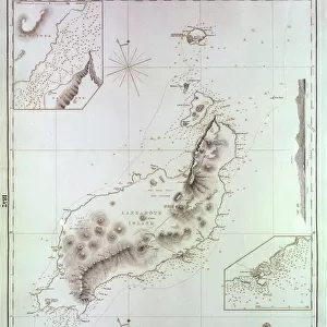
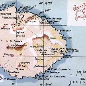
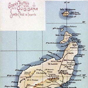
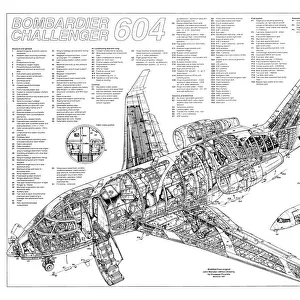
Map of the Canary Archipelago, showing the seven islands, Hierro, La Palma, Gomera, Tenerife, Gran Canaria, Fuerteventura, Lanzarote, as well as the two smaller islands, Graciosa and Alegranza. Date: circa 1908
Mary Evans Picture Library makes available wonderful images created for people to enjoy over the centuries
Media ID 14262722
© Mary Evans / Pharcide
Archipelago Atlantic Canaria Canaries Canary Cruz Gran Hierro Maps Palma Quisisana Tenerife Fuerteventura Gomera
Greetings Card (7"x5")
Brighten someone's day with a piece of exotic beauty! Our Map of the Canary Archipelago greetings cards, from the Media Storehouse collection, feature an intricately detailed and captivating map of the seven islands - Hierro, La Palma, Gomera, Tenerife, Gran Canaria, Fuerteventura, and Lanzarote, as well as the smaller islands Graciosa and Alegranza. This stunning image, sourced from Mary Evans Prints Online, is sure to transport your recipient to the sun-soaked shores of the Canaries. Perfect for travel enthusiasts, history buffs, or anyone in need of a tropical escape, these greetings cards are a thoughtful and unique way to express your warmest wishes.
Folded Greeting Cards (12.5x17.5 cm) have a laminate finish and are supplied with an envelope. The front and inside can be personalised with text in a selection of fonts, layouts and colours.
Greetings Cards suitable for Birthdays, Weddings, Anniversaries, Graduations, Thank You and much more
Estimated Product Size is 12.5cm x 17.5cm (4.9" x 6.9")
These are individually made so all sizes are approximate
Artwork printed orientated as per the preview above, with landscape (horizontal) or portrait (vertical) orientation to match the source image.
EDITORS COMMENTS
Step back in time with this map print of the Canary Archipelago from the early 1900s. Dating back to circa 1908, this map offers a glimpse into the past, showcasing the seven main islands of the Canaries - Hierro, La Palma, Gomera, Tenerife, Gran Canaria, Fuerteventura, and Lanzarote. The two smaller islands, Graciosa and Alegranza, are also depicted in this intricate and detailed representation of the Atlantic Ocean's most beautiful island chain. The Canary Islands, located off the northwest coast of Africa, have long been a popular destination for travelers seeking sun, sand, and adventure. This map, with its vibrant colors and clear labeling, would have been an essential tool for navigators and explorers of the era, guiding them through the waters of the Atlantic and helping them plan their journeys to these enchanting islands. The map's borders are adorned with intricate illustrations of the iconic Quisisana Hotel and the bustling port of Santa Cruz de Tenerife, offering a glimpse into the rich history and culture of the Canaries. The islands' diverse landscapes, from the lush greenery of La Palma and Gomera to the volcanic terrain of Tenerife and Fuerteventura, are beautifully represented in this stunning map print. Whether you're an avid collector of historical maps or simply a lover of all things Canary Islands, this map print is a must-have addition to your decor. Hang it in your home or office to transport yourself to a time when exploration and discovery were the driving forces of human curiosity.
MADE IN AUSTRALIA
Safe Shipping with 30 Day Money Back Guarantee
FREE PERSONALISATION*
We are proud to offer a range of customisation features including Personalised Captions, Color Filters and Picture Zoom Tools
SECURE PAYMENTS
We happily accept a wide range of payment options so you can pay for the things you need in the way that is most convenient for you
* Options may vary by product and licensing agreement. Zoomed Pictures can be adjusted in the Cart.