Greetings Card > Popular Themes > Railway Posters
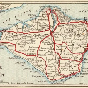
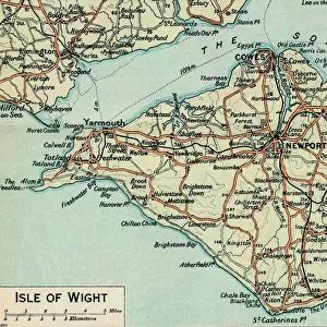
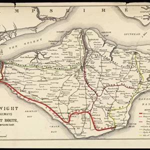
Greetings Card : Map of Isle of Wight


![]()
Cards from Mary Evans Picture Library
Map of Isle of Wight
A Map of the Isle of Wight, showing the internal railway system and the new & short route between the island and the Hampshire coast
Mary Evans Picture Library makes available wonderful images created for people to enjoy over the centuries
Media ID 4348747
© Mary Evans Picture Library 2015 - https://copyrighthub.org/s0/hub1/creation/maryevans/MaryEvansPictureID/10186021
1874 Connections Engineering Hampshire Internal Isle Links Maps Plans System Wight Short
Greetings Card (7"x5")
Introducing the latest addition to our Media Storehouse Greetings Cards collection: a charming Map of the Isle of Wight card. This beautifully detailed design, sourced from Mary Evans Prints Online, showcases an antique map of the Isle of Wight with the internal railway system and the new route between the island and the Hampshire coast. Perfect for those with a love for history or a connection to the Isle of Wight, this card is sure to bring a touch of nostalgia and character to any message. Add a personal touch with your own message inside and make someone's day. Order yours today and let the adventure begin!
Folded Greeting Cards (12.5x17.5 cm) have a laminate finish and are supplied with an envelope. The front and inside can be personalised with text in a selection of fonts, layouts and colours.
Greetings Cards suitable for Birthdays, Weddings, Anniversaries, Graduations, Thank You and much more
Estimated Product Size is 12.5cm x 17.5cm (4.9" x 6.9")
These are individually made so all sizes are approximate
Artwork printed orientated as per the preview above, with landscape (horizontal) or portrait (vertical) orientation to match the source image.
FEATURES IN THESE COLLECTIONS
> Europe
> United Kingdom
> England
> Hampshire
> Related Images
> Europe
> United Kingdom
> England
> Isle of Wight
> Related Images
> Maps and Charts
> Early Maps
> Maps and Charts
> Related Images
> Popular Themes
> Railway Posters
EDITORS COMMENTS
This vintage print of a Map of the Isle of Wight from 1874 offers a fascinating glimpse into the historical engineering and transport history of this picturesque island off the coast of Hampshire, England. The detailed map showcases not only the internal railway system that once connected various parts of the Isle, but also highlights a new and short route between the island and the Hampshire coast.
The intricate network of railway lines depicted on this map provides insight into how people traveled around the Isle of Wight in the late 19th century, offering a window into transportation methods long past. The inclusion of plans for connections and links further emphasizes the importance placed on efficient travel within this small yet significant British isle.
As we study this piece, we are reminded of how crucial railways were to shaping communities and facilitating movement during an era when horse-drawn carriages still shared roads with early automobiles. This print serves as both a historical document and a work of art, showcasing not just geographical information but also reflecting societal values and priorities at that time.
For history buffs, transportation enthusiasts, or anyone with an interest in British coastal regions, this Map of Isle of Wight print is sure to spark curiosity and appreciation for bygone eras.
MADE IN AUSTRALIA
Safe Shipping with 30 Day Money Back Guarantee
FREE PERSONALISATION*
We are proud to offer a range of customisation features including Personalised Captions, Color Filters and Picture Zoom Tools
SECURE PAYMENTS
We happily accept a wide range of payment options so you can pay for the things you need in the way that is most convenient for you
* Options may vary by product and licensing agreement. Zoomed Pictures can be adjusted in the Cart.