Greetings Card > Europe > United Kingdom > England > Manchester > Manchester
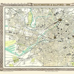
Greetings Card : Map / Manchester 1878


![]()
Cards from Mary Evans Picture Library
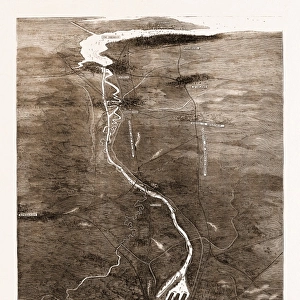
Map / Manchester 1878
Map of Manchester and its environs
Mary Evans Picture Library makes available wonderful images created for people to enjoy over the centuries
Media ID 608785
© Mary Evans Picture Library 2015 - https://copyrighthub.org/s0/hub1/creation/maryevans/MaryEvansPictureID/10113946
Greetings Card (7"x5")
Discover the charm of yesteryears with our exclusive range of greeting cards from Media Storehouse, featuring the captivating "Map / Manchester 1878" by Mary Evans Picture Library from Mary Evans Prints Online. This beautifully intricate map of Manchester and its surroundings, hailing from 1878, transports you back in time, making it an ideal gift for history enthusiasts and those with a love for the city's rich past. The detailed illustrations, coupled with the vintage aesthetic, add a touch of elegance and nostalgia to any occasion. Whether it's a birthday, anniversary, or just to say hello, our Manchester 1878 greeting cards are sure to leave a lasting impression.
Folded Greeting Cards (12.5x17.5 cm) have a laminate finish and are supplied with an envelope. The front and inside can be personalised with text in a selection of fonts, layouts and colours.
Greetings Cards suitable for Birthdays, Weddings, Anniversaries, Graduations, Thank You and much more
Estimated Product Size is 12.5cm x 17.5cm (4.9" x 6.9")
These are individually made so all sizes are approximate
Artwork printed orientated as per the preview above, with landscape (horizontal) orientation to match the source image.
FEATURES IN THESE COLLECTIONS
> Europe
> United Kingdom
> England
> Manchester
> Manchester
> Europe
> United Kingdom
> England
> Maps
> Europe
> United Kingdom
> England
> Posters
> Europe
> United Kingdom
> England
> Related Images
> Maps and Charts
> Early Maps
> Maps and Charts
> Related Images
EDITORS COMMENTS
This stunning print of a map of Manchester from 1878 offers a fascinating glimpse into the history and development of this iconic city in England. The intricate details captured in this map provide a snapshot of Manchester and its environs during a pivotal moment in time, showcasing the layout of streets, landmarks, and neighborhoods as they existed over 140 years ago.
As we study this historical map, we can see how the city has evolved and grown over the decades, with changes in infrastructure, urban planning, and population density all reflected in the cartographic representation. From bustling city centers to sprawling suburbs, every corner of Manchester is meticulously documented on this vintage map.
The rich history embedded within these lines and symbols invites us to explore the past and imagine what life was like for residents of Manchester in the late 19th century. It serves as a reminder of how far the city has come since then while also highlighting its enduring legacy as an industrial powerhouse with a vibrant cultural heritage.
Whether you're a history buff, geography enthusiast or simply curious about Manchester's roots, this print is sure to spark your imagination and deepen your appreciation for one of England's most dynamic cities.
MADE IN AUSTRALIA
Safe Shipping with 30 Day Money Back Guarantee
FREE PERSONALISATION*
We are proud to offer a range of customisation features including Personalised Captions, Color Filters and Picture Zoom Tools
SECURE PAYMENTS
We happily accept a wide range of payment options so you can pay for the things you need in the way that is most convenient for you
* Options may vary by product and licensing agreement. Zoomed Pictures can be adjusted in the Cart.