Greetings Card > South America > Brazil > Maps
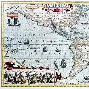
Greetings Card : Map /s America / Brazil 16C


![]()
Cards from Mary Evans Picture Library
Map /s America / Brazil 16C
Map of Brazil
Mary Evans Picture Library makes available wonderful images created for people to enjoy over the centuries
Media ID 582578
© Mary Evans Picture Library 2015 - https://copyrighthub.org/s0/hub1/creation/maryevans/MaryEvansPictureID/10030239
Greetings Card (7"x5")
Introducing the latest addition to our Greetings Cards collection from Media Storehouse - a beautifully designed card featuring a captivating map of Brazil from the Mary Evans Picture Library. Travel back in time to the 16th century with this intricately detailed map of South America, showcasing the vibrant colors and rich history of Brazil. This card is perfect for any occasion, whether it's for a friend's birthday, a thoughtful thank you, or simply to brighten someone's day. With its striking design and high-quality finish, this card is sure to leave a lasting impression. Add a personal touch with a heartfelt message and send a piece of history straight to their doorstep. Discover the wonders of Brazil and express your feelings in one beautifully crafted card.
Folded Greeting Cards (12.5x17.5 cm) have a laminate finish and are supplied with an envelope. The front and inside can be personalised with text in a selection of fonts, layouts and colours.
Greetings Cards suitable for Birthdays, Weddings, Anniversaries, Graduations, Thank You and much more
Estimated Product Size is 12.5cm x 17.5cm (4.9" x 6.9")
These are individually made so all sizes are approximate
Artwork printed orientated as per the preview above, with landscape (horizontal) or portrait (vertical) orientation to match the source image.
FEATURES IN THESE COLLECTIONS
> Maps and Charts
> Early Maps
> Maps and Charts
> Related Images
> South America
> Brazil
> Maps
> South America
> Brazil
> Related Images
> South America
> Related Images
> Mary Evans Prints Online
> Maps
EDITORS COMMENTS
This stunning print captures a piece of history with the detailed map of Brazil from the 16th century. The intricate lines and markings on the map provide a glimpse into what the country looked like over four centuries ago. From the coastal cities to the vast interior regions, this map showcases Brazil's diverse geography and rich history.
Created in 1582, this historical artifact offers a unique perspective on South America during this time period. It serves as a reminder of the explorers who first mapped out these lands and paved the way for future generations. The attention to detail in this map is truly remarkable, showcasing rivers, mountains, and settlements with precision.
As we gaze upon this piece from Mary Evans Picture Library, we are transported back in time to an era of discovery and exploration. The colors may have faded slightly over time, but the significance of this map remains intact. It is a testament to human ingenuity and curiosity about our world.
Whether you are a history buff or simply appreciate fine artistry, this Map of Brazil from the 16th century is sure to captivate your imagination. Display it proudly in your home or office as a conversation starter and a tribute to Brazil's fascinating past.
MADE IN AUSTRALIA
Safe Shipping with 30 Day Money Back Guarantee
FREE PERSONALISATION*
We are proud to offer a range of customisation features including Personalised Captions, Color Filters and Picture Zoom Tools
SECURE PAYMENTS
We happily accept a wide range of payment options so you can pay for the things you need in the way that is most convenient for you
* Options may vary by product and licensing agreement. Zoomed Pictures can be adjusted in the Cart.