Greetings Card > Maps and Charts > Early Maps
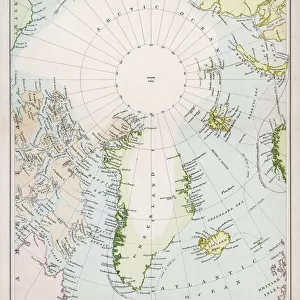
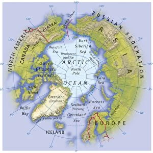
Greetings Card : Map / Arctic Circle 1895


![]()
Cards from Mary Evans Picture Library
Map / Arctic Circle 1895
Map of the Arctic Circle and surrounding areas
Mary Evans Picture Library makes available wonderful images created for people to enjoy over the centuries
Media ID 608851
© Mary Evans Picture Library 2015 - https://copyrighthub.org/s0/hub1/creation/maryevans/MaryEvansPictureID/10114181
Arctic Circle Maps Surrounding 1895
Greetings Card (7"x5")
Introducing the captivating selection of Arctic Circle greeting cards from Media Storehouse, brought to you in collaboration with Mary Evans Picture Library from Mary Evans Prints Online. These exquisite cards feature the breathtaking "Map / Arctic Circle 1895" image, which transports you to a bygone era of exploration and adventure. With intricate details of the Arctic Circle and its surrounding areas, these cards are perfect for those who appreciate the beauty of historical maps and the allure of the polar regions. Express your thoughts and feelings with a touch of history and class, making every message a journey to remember.
Folded Greeting Cards (12.5x17.5 cm) have a laminate finish and are supplied with an envelope. The front and inside can be personalised with text in a selection of fonts, layouts and colours.
Greetings Cards suitable for Birthdays, Weddings, Anniversaries, Graduations, Thank You and much more
Estimated Product Size is 12.5cm x 17.5cm (4.9" x 6.9")
These are individually made so all sizes are approximate
Artwork printed orientated as per the preview above, with landscape (horizontal) orientation to match the source image.
FEATURES IN THESE COLLECTIONS
> Maps and Charts
> Early Maps
> Maps and Charts
> Related Images
> Popular Themes
> Maps and Charts
EDITORS COMMENTS
This stunning print captures a piece of history with the Map of the Arctic Circle from 1895. The intricate details and design of this map provide a fascinating glimpse into the past, showcasing the geographical layout of the Arctic Circle and its surrounding areas during that time period.
The historical significance of this map is undeniable, as it offers valuable insights into how explorers navigated through these icy waters over a century ago. From the rugged terrain to the icy waters, every element on this map tells a story of adventure and discovery in one of Earth's most remote regions.
As we study this map closely, we can't help but marvel at the dedication and bravery of those who ventured into these uncharted territories in search of new lands and resources. The precision and accuracy with which this map was created are truly remarkable, highlighting both scientific knowledge and artistic skill.
Whether you're a history buff or simply appreciate beautiful cartography, this Map of the Arctic Circle from 1895 is sure to captivate your imagination. It serves as a reminder of our planet's vastness and diversity, urging us to explore beyond our comfort zones and embrace new horizons just waiting to be discovered.
MADE IN AUSTRALIA
Safe Shipping with 30 Day Money Back Guarantee
FREE PERSONALISATION*
We are proud to offer a range of customisation features including Personalised Captions, Color Filters and Picture Zoom Tools
SECURE PAYMENTS
We happily accept a wide range of payment options so you can pay for the things you need in the way that is most convenient for you
* Options may vary by product and licensing agreement. Zoomed Pictures can be adjusted in the Cart.