Greetings Card > Maps and Charts > Americas
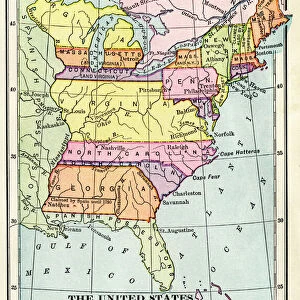
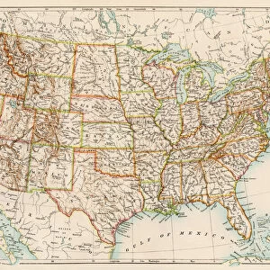
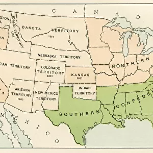
Greetings Card : United States during the Civil War


![]()
Cards from North Wind
United States during the Civil War
Map of the United States 1861 to 1865.
Printed color lithograph of a 19th-century illustration
North Wind Picture Archives brings history to life with stock images and hand-colored illustrations
Media ID 5877464
© North Wind Picture Archives
1860s America Civil War Confederacy North Northern Secession South Southern Territory Confederate States
Greetings Card (7"x5")
"Step back in time with our exclusive range of Greeting Cards from Media Storehouse, featuring a captivating image of the United States during the pivotal era of the Civil War. This stunning, printed color lithograph, sourced from North Wind Picture Archives, showcases an intricately detailed map of the United States from 1861 to 1865. Perfect for history enthusiasts, this card carries the weight of a significant period in American history, making it an ideal gift for any special occasion or simply as a thoughtful gesture to send to a loved one. Let the rich history of the Civil War come alive through the pages of our Greeting Cards."
Folded Greeting Cards (12.5x17.5 cm) have a laminate finish and are supplied with an envelope. The front and inside can be personalised with text in a selection of fonts, layouts and colours.
Greetings Cards suitable for Birthdays, Weddings, Anniversaries, Graduations, Thank You and much more
Estimated Product Size is 12.5cm x 17.5cm (4.9" x 6.9")
These are individually made so all sizes are approximate
Artwork printed orientated as per the preview above, with landscape (horizontal) or portrait (vertical) orientation to match the source image.
FEATURES IN THESE COLLECTIONS
> Maps and Charts
> Related Images
> North America
> Related Images
> South America
> Related Images
> North Wind Picture Archives
> American history
> North Wind Picture Archives
> Maps
EDITORS COMMENTS
This print showcases a vividly colored lithograph of an illustration from the 19th century, depicting the United States during one of its most tumultuous periods - the Civil War. The map, created between 1861 and 1865, offers a fascinating glimpse into American history and serves as a visual representation of this divided nation. The image captures both the northern and southern states, showcasing their distinct territories within North America. It symbolizes not only geographical boundaries but also the ideological divide that led to secession and ultimately sparked this devastating conflict. With intricate details and traditional artistic style, this vintage print transports us back to a time when America was torn apart by differing beliefs on slavery, state rights, and national unity. It serves as a powerful reminder of our nation's complex past while highlighting the struggles faced by both sides during this pivotal era. As we observe this historic illustration with awe-inspiring curiosity, it prompts reflection on how far we have come since those dark days in our history. This artwork invites us to appreciate the resilience shown by Americans throughout generations as they worked towards healing wounds caused by war. Whether displayed in classrooms or historical institutions, this remarkable piece sparks conversations about unity amidst division and reminds us all of our shared heritage – one that continues to shape who we are today.
MADE IN AUSTRALIA
Safe Shipping with 30 Day Money Back Guarantee
FREE PERSONALISATION*
We are proud to offer a range of customisation features including Personalised Captions, Color Filters and Picture Zoom Tools
SECURE PAYMENTS
We happily accept a wide range of payment options so you can pay for the things you need in the way that is most convenient for you
* Options may vary by product and licensing agreement. Zoomed Pictures can be adjusted in the Cart.