Greetings Card > Arts > Artists > O > Oceanic Oceanic
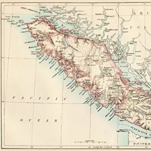
Greetings Card : New Brunswick and Nova Scotia, 1870s


![]()
Cards from North Wind
New Brunswick and Nova Scotia, 1870s
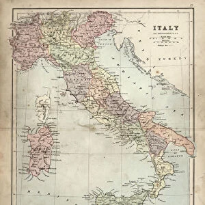
Map of Nova Scotia, Prince Edward Island, and New Brunswick, 1870s.
Printed color lithograph
North Wind Picture Archives brings history to life with stock images and hand-colored illustrations
Media ID 5879743
© North Wind Picture Archives
1870s Atlantic Coast Atlantic Ocean Canada Canadian Island Maritime Provinces Nova Scotia Bay Of Fundy Maritimes New Brunswick Prince Edward Island
Greetings Card (7"x5")
"Step back in time with our exquisite range of greeting cards from Media Storehouse. This particular design showcases a captivating map of New Brunswick and Nova Scotia, as they appeared in the 1870s, taken from the North Wind Picture Archives. The intricate details of this printed color lithograph transport you to an era of exploration and discovery. Perfect for history enthusiasts or those with connections to the region, these vintage greeting cards are a thoughtful and unique way to express your sentiments. Add a touch of nostalgia to your correspondence with this beautiful piece of historical art."
Folded Greeting Cards (12.5x17.5 cm) have a laminate finish and are supplied with an envelope. The front and inside can be personalised with text in a selection of fonts, layouts and colours.
Greetings Cards suitable for Birthdays, Weddings, Anniversaries, Graduations, Thank You and much more
Estimated Product Size is 12.5cm x 17.5cm (4.9" x 6.9")
These are individually made so all sizes are approximate
Artwork printed orientated as per the preview above, with landscape (horizontal) or portrait (vertical) orientation to match the source image.
FEATURES IN THESE COLLECTIONS
> Arts
> Artists
> O
> Oceanic Oceanic
> Maps and Charts
> Related Images
> North America
> Canada
> Maps
> North America
> Canada
> Related Images
> North America
> Related Images
> Popular Themes
> North Island
> North Wind Picture Archives
> Canadian history
> North Wind Picture Archives
> Maps
EDITORS COMMENTS
This vintage print takes us back to the 1870s, offering a glimpse into the rich history and heritage of Canada's Maritime Provinces. The beautifully detailed map showcases the enchanting landscapes of New Brunswick, Nova Scotia, and Prince Edward Island, capturing the essence of this bygone era. As we study this illustration, we are transported to a time when traditional cartography was an art form in itself. The vibrant printed colors bring life to each province's unique features: from the rugged Atlantic coastlines that meet the vastness of the ocean to the intricate network of rivers and bays that crisscross these lands. The significance of this piece lies not only in its artistic value but also in its historical importance. It serves as a window into North America's past, allowing us to trace how these provinces were shaped over time. From Bay of Fundy's powerful tides to Prince Edward Island's charming island landscape, every detail on this map tells a story waiting to be discovered. Whether you have roots in these regions or simply appreciate their beauty and cultural significance, this print is sure to captivate your imagination. It stands as a testament to our connection with nature and our desire for exploration – reminding us that even within modernity lies a deep appreciation for our roots and traditions.
MADE IN AUSTRALIA
Safe Shipping with 30 Day Money Back Guarantee
FREE PERSONALISATION*
We are proud to offer a range of customisation features including Personalised Captions, Color Filters and Picture Zoom Tools
SECURE PAYMENTS
We happily accept a wide range of payment options so you can pay for the things you need in the way that is most convenient for you
* Options may vary by product and licensing agreement. Zoomed Pictures can be adjusted in the Cart.