Greetings Card > Europe > United Kingdom > England > Yorkshire > Sheffield
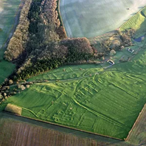
Greetings Card : A survey of a parcel of Land called Platts... [Platts Farm, Ughill], 1728
![A survey of a parcel of Land called Platts... [Platts Farm, Ughill], 1728](/image/716/19225923/19225923_600_600_80324_0_fill_0_28a51b5a40de6b057828c9b89c0e65cc.jpg.webp "A survey of a parcel of Land called Platts... [Platts Farm, Ughill], 1728")

![A survey of a parcel of Land called Platts... [Platts Farm, Ughill], 1728](/p/716/survey-parcel-land-called-platts-19225923.jpg.webp "A survey of a parcel of Land called Platts... [Platts Farm, Ughill], 1728")

![]()
Cards from Sheffield City Archives
A survey of a parcel of Land called Platts... [Platts Farm, Ughill], 1728
Scale 4 chains : 1 inch [20 inches : 1 mile].
Surveyor: William Kitchin.
Small perspective drawing of the farmhouse; dividers and scale and compass rose; acreage given on the map.
From an original at Sheffield Libraries: arc03005
Sheffield City Archives and Local Studies Library has an unrivalled collection of images of Sheffield, England
Media ID 19225923
© Sheffield City Council - All Rights Reserved
Greetings Card (7"x5")
Step back in time with our exquisite Platts Farm greeting card from the Media Storehouse collection. This beautifully detailed, 18th-century survey of Platts Farm in Ughill, Sheffield, showcases a rich historical perspective. Captured from Sheffield City Archives, this meticulously crafted map, drawn by surveyor William Kitchin, includes a small perspective drawing of the farmhouse, dividers, scale, and compass rose. Delve into the past as you share this unique, acreage-given map as a thoughtful gift or keep it as a cherished memento. Experience history in every inch of this captivating card.
Folded Greeting Cards (12.5x17.5 cm) have a laminate finish and are supplied with an envelope. The front and inside can be personalised with text in a selection of fonts, layouts and colours.
Greetings Cards suitable for Birthdays, Weddings, Anniversaries, Graduations, Thank You and much more
Estimated Product Size is 12.5cm x 17.5cm (4.9" x 6.9")
These are individually made so all sizes are approximate
Artwork printed orientated as per the preview above, with landscape (horizontal) or portrait (vertical) orientation to match the source image.
FEATURES IN THESE COLLECTIONS
> Animals
> Insects
> Hemiptera
> Rose Scale
> Arts
> Artists
> S
> William Small
> Europe
> France
> Canton
> Landes
> Europe
> United Kingdom
> England
> Yorkshire
> Related Images
> Europe
> United Kingdom
> England
> Yorkshire
> Sheffield
> Maps and Charts
> Related Images
> Sheffield City Archives
> Maps and Plans
> Maps of Bradfield
EDITORS COMMENTS
This print from Sheffield City Archives takes us back to the year 1728, offering a glimpse into the past with its detailed survey of Platts Farm in Ughill. The surveyor behind this remarkable piece is none other than William Kitchin, whose expertise shines through in every aspect of this map. The print showcases not only the boundaries and features of Platts Farm but also provides a small perspective drawing of the farmhouse itself. This charming addition allows us to visualize what life was like on this Yorkshire farm over two centuries ago. Accompanying dividers and scale, as well as a compass rose, further enhance our understanding of the land's layout and orientation. It is fascinating to see how meticulous attention was paid to accurately represent every inch of this parcel. Additionally, the acreage given on the map adds another layer of information for those interested in understanding the size and scope of Platts Farm during that time period. Preserved by Sheffield Libraries, this original document (arc03005) offers an invaluable historical resource for researchers and enthusiasts alike. It serves as a testament to both Sheffield's rich heritage and its commitment to preserving important archival materials
MADE IN AUSTRALIA
Safe Shipping with 30 Day Money Back Guarantee
FREE PERSONALISATION*
We are proud to offer a range of customisation features including Personalised Captions, Color Filters and Picture Zoom Tools
SECURE PAYMENTS
We happily accept a wide range of payment options so you can pay for the things you need in the way that is most convenient for you
* Options may vary by product and licensing agreement. Zoomed Pictures can be adjusted in the Cart.

![A map of Wm. Carrs Farm at Stanington [Stannington], 1747](/sq/716/map-wm-carrs-farm-stanington-stannington-1747-19192400.jpg.webp)
![Maps of Several Parcels of Land proposed to be exchanged, Bradfield, [c. 1750 - 1760]](/sq/716/maps-parcels-land-proposed-exchanged-bradfield-19192402.jpg.webp)