Greetings Card > North America > Puerto Rico > Maps
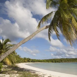
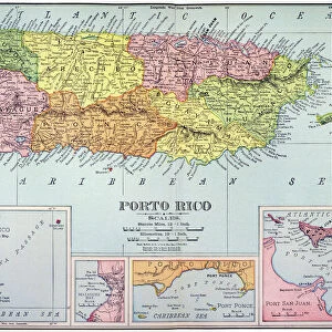
Greetings Card : Map of Puerto Rico, close-up


![]()
Cards from Universal Images Group (UIG)
Map of Puerto Rico, close-up
Universal Images Group (UIG) manages distribution for many leading specialist agencies worldwide
Media ID 9540221
© Dorling Kindersley/UIG
Caribbean Digitally Generated Direction Guidance Island Puerto Rico State Text Western Script Us Territory
Greetings Card (7"x5")
Brighten someone's day with a thoughtful and unique greeting from Media Storehouse. Our collection features this stunning close-up image of "Map of Puerto Rico" by Dorling Kindersley from Universal Images Group (UIG). This captivating card design showcases intricate details of the island's terrain, making it an ideal choice for those with a love for geography or travel. Express your sentiments with a touch of culture and adventure. Order now and let the recipient feel the warmth and charm of Puerto Rico in every card you send.
Folded Greeting Cards (12.5x17.5 cm) have a laminate finish and are supplied with an envelope. The front and inside can be personalised with text in a selection of fonts, layouts and colours.
Greetings Cards suitable for Birthdays, Weddings, Anniversaries, Graduations, Thank You and much more
Estimated Product Size is 12.5cm x 17.5cm (4.9" x 6.9")
These are individually made so all sizes are approximate
Artwork printed orientated as per the preview above, with landscape (horizontal) or portrait (vertical) orientation to match the source image.
FEATURES IN THESE COLLECTIONS
> Maps and Charts
> Related Images
> North America
> Puerto Rico
> Maps
> North America
> Puerto Rico
> Related Images
> Universal Images Group (UIG)
> Illustrations
> Illustrations 1
EDITORS COMMENTS
This vibrant and detailed close-up of a map of Puerto Rico is a true masterpiece in cartography. Created by the talented Dorling Kindersley, this square image captures the essence of this beautiful Caribbean island with its intricate details and vivid colors. The map showcases Puerto Rico's physical geography, providing viewers with an immersive experience that allows them to explore every corner of the island. From its stunning coastline to its lush mountains, this illustration beautifully represents the diverse landscapes found within Puerto Rico. With Western script text carefully placed throughout the map, it serves as both a visual delight and a practical tool for navigation. Whether you're planning your next adventure or simply admiring the artistry behind it, this print offers guidance and direction for those curious about exploring all that Puerto Rico has to offer. As a US territory, Puerto Rico holds a unique place in both history and culture. This digitally generated artwork pays homage to its significance while showcasing Dorling Kindersley's expertise in creating visually captivating maps. Without any people present in the image, all attention is drawn solely towards the beauty of nature and topography. This print would make an excellent addition to any collection or serve as an educational resource for those interested in learning more about Puerto Rican geography.
MADE IN AUSTRALIA
Safe Shipping with 30 Day Money Back Guarantee
FREE PERSONALISATION*
We are proud to offer a range of customisation features including Personalised Captions, Color Filters and Picture Zoom Tools
SECURE PAYMENTS
We happily accept a wide range of payment options so you can pay for the things you need in the way that is most convenient for you
* Options may vary by product and licensing agreement. Zoomed Pictures can be adjusted in the Cart.