Home > Arts > Artists > O > Oceanic Oceanic
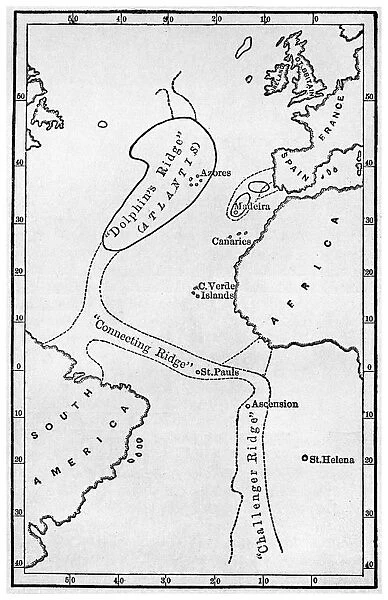
Atlantis: a map showing the location of the mythical continent, c1882 (1956)
![]()

Wall Art and Photo Gifts from Heritage Images
Atlantis: a map showing the location of the mythical continent, c1882 (1956)
Atlantis: a map showing the location of the mythical continent, c1882 (1956). Showing its islands and connecting ridges, from deep sea soundings, from Atlantis: the Antediluvian World by Ignatius L Donnelly. Donnelly (1831-1901) was an American politician, writer and fringe scientist. His book on Atlantis, published in 1882, was a best seller, creating a mania for the idea of the legendary continent that persists to this day
Heritage Images features heritage image collections
Media ID 14949697
© The Print Collector / Heritage-Images
Atlantic Ocean Atlantis Cartography Legend Legendary Map Making Mythical Ocean Print Collector11 Theory Donnelly Mid Atlantic Ridge
FEATURES IN THESE COLLECTIONS
> Arts
> Artists
> O
> Oceanic Oceanic
> Maps and Charts
> Related Images
> Maps and Charts
> World
> People
> Politicians
> Science
> Scientists
EDITORS COMMENTS
This print showcases a map of Atlantis, the mythical continent that has fascinated people for centuries. Created in 1882 by Ignatius L Donnelly, an American politician, writer, and fringe scientist, this map became a bestseller and ignited a widespread obsession with the legendary land. The intricate details of the map reveal the islands and connecting ridges of Atlantis as depicted from deep sea soundings. The mid-Atlantic ridge is prominently featured, emphasizing its significance in supporting theories about the lost civilization's location. Ignatius L Donnelly's book on Atlantis further fueled public interest in this enigmatic place. Published during the 19th century, it sparked a mania that continues to captivate imaginations today. This image serves as a reminder of how influential Donnelly's work was in shaping our perception of Atlantis. As we gaze upon this monochrome masterpiece, we are transported to an era when cartography played an essential role in exploring both real and mythical lands. The print collector responsible for preserving this piece allows us to appreciate not only its historical value but also its artistic beauty. While commercial use may be excluded from discussion here, it is impossible to overlook the enduring allure of Atlantis as depicted on this remarkable map. Its presence within popular culture remains strong due to works like Ignatius L Donnelly's exploration into its existence – forever immortalized through prints such as these.
MADE IN AUSTRALIA
Safe Shipping with 30 Day Money Back Guarantee
FREE PERSONALISATION*
We are proud to offer a range of customisation features including Personalised Captions, Color Filters and Picture Zoom Tools
SECURE PAYMENTS
We happily accept a wide range of payment options so you can pay for the things you need in the way that is most convenient for you
* Options may vary by product and licensing agreement. Zoomed Pictures can be adjusted in the Cart.


