Home > Animals > Mammals > Muridae > Desert Mouse
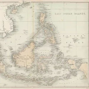
'Carte des pluies; L'Ouest Africain, 1914. Creator: Unknown

![]()
Wall Art and Photo Gifts from Heritage Images
'Carte des pluies; L'Ouest Africain, 1914. Creator: Unknown
'Carte des pluies; L'Ouest Africain, 1914. From "Grande Geographie Bong Illustree", 1914
Heritage Images features heritage image collections
Media ID 36295223
© The Print Collector/Heritage Images
Atlantic Ocean Cartography Central Africa Central African Climate Desert Equatorial Gulf Gulf Of Guinea Map Making Mapmaking Ocean Sahara Sahara Desert Africa West Africa West African Congo Basin Rainfall
FEATURES IN THESE COLLECTIONS
> Africa
> Equatorial Guinea
> Maps
> Africa
> Equatorial Guinea
> Related Images
> Africa
> Guinea
> Related Images
> Animals
> Mammals
> Muridae
> Desert Mouse
Carte des pluies; L'Ouest Africain, 1914
EDITORS COMMENTS
is an intriguing and historic map print depicting the rainfall patterns in West Africa during the early 20th century. The creator of this map remains unknown, but it was published in the French magazine "Grande Geographie Bong Illustree" in 1914. The map provides a detailed representation of the climate and geographical features of West Africa, with a focus on rainfall distribution. The Central African region, including the Congo Basin, is prominently featured, displaying the heavy rainfall patterns in the equatorial regions contrasted with the arid Sahara Desert to the north. The Atlantic Ocean, with its Gulf of Guinea, is also shown, highlighting the coastal areas and the impact of the ocean on the climate. The mapmaking process involved intricate engraving techniques, resulting in a visually stunning representation of the region. The use of color and contrast effectively illustrates the varying rainfall patterns, making it an essential tool for understanding the climatic conditions of West Africa during this period. The map's historical significance lies in its representation of French colonial influence in Africa. France had significant territorial holdings in West Africa, and this map reflects the French interest in understanding the geography and climate of their colonies. The map's publication in a French magazine further underscores this point. Despite the unknown creator, "Carte des pluies; L'Ouest Africain, 1914" is an essential addition to any collection of historical maps or African studies. Its intricate detail and beautiful design make it a fascinating glimpse into the past, providing valuable insights into the climate and geography of West Africa during the early 20th century.
MADE IN AUSTRALIA
Safe Shipping with 30 Day Money Back Guarantee
FREE PERSONALISATION*
We are proud to offer a range of customisation features including Personalised Captions, Color Filters and Picture Zoom Tools
SECURE PAYMENTS
We happily accept a wide range of payment options so you can pay for the things you need in the way that is most convenient for you
* Options may vary by product and licensing agreement. Zoomed Pictures can be adjusted in the Cart.