Home > Arts > Artists > C > William Caxton
Map of the Italian Fighting Front, 1919. Creator: George Philip & Son Ltd

![]()
Wall Art and Photo Gifts from Heritage Images
Map of the Italian Fighting Front, 1919. Creator: George Philip & Son Ltd
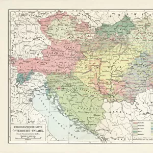
Map of the Italian Fighting Front, 1919. Map showing north-eastern Italy, the Trentino and part of southern Austria during the First World War, 1914-1919. Fortresses, fortified towns, naval arsenals and forts, railways and roads are indicated. From " The History of the Great European War: its causes and effects", Vol. VI, by W. Stanley Macbean Knight. [Caxton Pulishing Company, Limited, London, 1919]
Heritage Images features heritage image collections
Media ID 19047803
© The Print Collector/Heritage Images
Adriatic And Son Ltd Austria Hungary Austro Hungarian Austro Hungarian Empire Caxton Publishing Company Caxton Pulishing Company Caxton Pulishing Company Lim Caxton Pulishing Company Limited Caxton Pulishing Company Ltd Friuli Venezia Giulia George Philip And Son George Philip And Son Ltd Knight Limited Philip Stanley Macbean Stanley Macbean Knight Territorial Territory Trieste Venice W Stanley Macbean W Stanley Macbean Knight William Stanley Macbean William Stanley Macbean Knight 1st World War
FEATURES IN THESE COLLECTIONS
> Arts
> Artists
> C
> William Caxton
> Europe
> Austria
> Related Images
> Europe
> Hungary
> Related Images
> Europe
> Italy
> Friuli-Venezia Giulia
> Related Images
Map of the Italian Fighting Front, 1919 - A Glimpse into the Complexities of World War I
EDITORS COMMENTS
. This print showcases a meticulously detailed map titled "Map of the Italian Fighting Front, 1919". Created by George Philip & Son Ltd, this historical artifact offers a fascinating insight into the intricate landscape of north-eastern Italy, Trentino, and parts of southern Austria during the First World War. The map not only highlights geographical features but also provides valuable information on fortresses, fortified towns, naval arsenals and forts, railways, and roads. It serves as an invaluable resource for understanding the strategic importance of various locations in this war-torn region. Published in "The History of the Great European War: its causes and effects". Volume VI by W. Stanley Macbean Knight in 1919 under Caxton Publishing Company Limited in London; this print is a testament to both its historical significance and artistic beauty. As we delve into this visual masterpiece, it becomes evident that it captures more than just territorial boundaries. It encapsulates an era defined by conflict and upheaval. The vibrant colors bring life to a period marked by intense struggles between nations. Through this image's lens lies a poignant reminder of humanity's resilience amidst chaos. It invites us to reflect upon the sacrifices made during World War I while offering an opportunity to appreciate how far we have come since those tumultuous times. Let us cherish this remarkable piece from Heritage Images as it transports us back to one chapter in our shared history—a chapter that shaped nations and transformed lives forever.
MADE IN AUSTRALIA
Safe Shipping with 30 Day Money Back Guarantee
FREE PERSONALISATION*
We are proud to offer a range of customisation features including Personalised Captions, Color Filters and Picture Zoom Tools
SECURE PAYMENTS
We happily accept a wide range of payment options so you can pay for the things you need in the way that is most convenient for you
* Options may vary by product and licensing agreement. Zoomed Pictures can be adjusted in the Cart.