Home > Europe > United Kingdom > England > Maps
Map of Libya, the Middle East and North Africa, 1478, reprinted 1889. Creator: Unknown

![]()
Wall Art and Photo Gifts from Heritage Images
Map of Libya, the Middle East and North Africa, 1478, reprinted 1889. Creator: Unknown
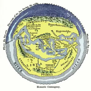
Map of Libya, the Middle East and North Africa, 1478, reprinted 1889
Heritage Images features heritage image collections
Media ID 36193949
© Heritage Art/Heritage Images
Libya North Africa Laid Paper Lithotint
FEATURES IN THESE COLLECTIONS
> Africa
> Libya
> Related Images
> Europe
> United Kingdom
> England
> Maps
> Europe
> United Kingdom
> Maps
> Historic
> Ancient artifacts and relics
> Maps and Charts
> Early Maps
EDITORS COMMENTS
This intriguing map print, titled "Map of Libya, the Middle East and North Africa," dates back to the 15th century, with a reprint in 1889. The creator of the original map remains unknown, but it is believed to be the work of Francesco Berlinghieri, an Italian cartographer. The map is a significant historical artifact, showcasing the geographical knowledge of the time, with Libya and the Middle East and North Africa regions depicted in great detail. The map is a lithograph on cream laid paper, a common printing technique of the 19th century. It is interesting to note that despite being a reprint from over 400 years later, the map remains relatively accurate in its depiction of the regions, with the borders of countries and the locations of major cities and landmarks largely corresponding to their current positions. The map offers a fascinating glimpse into the past, providing insights into the cultural and historical contexts of the Middle East and North Africa during the 15th century. It is also a testament to the enduring importance of cartography and the role it plays in shaping our understanding of the world. This map is part of the rich collection of prints and drawings at the Art Institute of Chicago, a renowned art museum and cultural institution in the United States. The map's intricate details and historical significance make it a must-see for anyone interested in art, history, or the cultural heritage of the Middle East and North Africa.
MADE IN AUSTRALIA
Safe Shipping with 30 Day Money Back Guarantee
FREE PERSONALISATION*
We are proud to offer a range of customisation features including Personalised Captions, Color Filters and Picture Zoom Tools
SECURE PAYMENTS
We happily accept a wide range of payment options so you can pay for the things you need in the way that is most convenient for you
* Options may vary by product and licensing agreement. Zoomed Pictures can be adjusted in the Cart.