Home > Europe > Russia > Maps
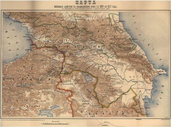
Map of military operations in the Transcaucasian region from 1809 to 1817, 1817
![]()

Wall Art and Photo Gifts from Heritage Images
Map of military operations in the Transcaucasian region from 1809 to 1817, 1817
Map of military operations in the Transcaucasian region from 1809 to 1817, 1817. Private Collection
Heritage Images features heritage image collections
Media ID 15031348
© Fine Art Images
1817 Anonymous Master Cartography Caucasus Color Photography Russian Empire South Caucasus Transcaucasia
FEATURES IN THESE COLLECTIONS
> Europe
> Russia
> Related Images
> Maps and Charts
> Related Images
EDITORS COMMENTS
This print showcases a remarkable piece of history - the "Map of military operations in the Transcaucasian region from 1809 to 1817,1817". With its vibrant colors and intricate details, this map takes us on a visual journey through time. The Transcaucasian region was at the center of intense military activities during this period, and this map provides invaluable insights into these operations. It offers a glimpse into the Russian Empire's expansionist ambitions as it sought to consolidate its control over the Caucasus. Created by an anonymous master, this fine art piece is not only a testament to their skill but also serves as an important historical document. Its cartographic precision allows us to trace the movements of armies and understand how political boundaries were shaped in that era. As we study this map, we are transported back to a tumultuous time when empires clashed and territories were fiercely contested. The South Caucasus becomes our backdrop for understanding geopolitical struggles and power dynamics. Preserved within a private collection, this photograph print ensures that future generations can appreciate both the beauty and significance of this historical artifact. It reminds us that behind every line on a map lies countless stories waiting to be discovered – tales of conquests, alliances, and human resilience against all odds.
MADE IN AUSTRALIA
Safe Shipping with 30 Day Money Back Guarantee
FREE PERSONALISATION*
We are proud to offer a range of customisation features including Personalised Captions, Color Filters and Picture Zoom Tools
SECURE PAYMENTS
We happily accept a wide range of payment options so you can pay for the things you need in the way that is most convenient for you
* Options may vary by product and licensing agreement. Zoomed Pictures can be adjusted in the Cart.


