Home > Europe > Russia > Maps
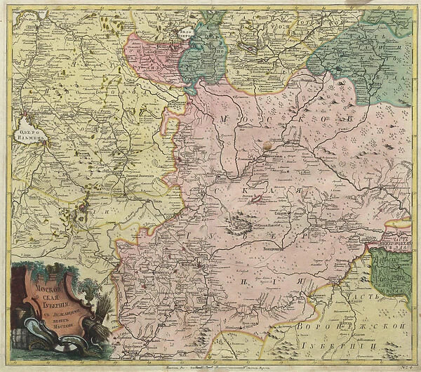
Map of Moscow governorate and parts of nearest provinces, 1745. Artist: Anonymous master
![]()

Wall Art and Photo Gifts from Heritage Images
Map of Moscow governorate and parts of nearest provinces, 1745. Artist: Anonymous master
Map of Moscow governorate and parts of nearest provinces, 1745. Found in the collection of the Academy of Sciences, Saint Petersburg
Heritage Images features heritage image collections
Media ID 15016218
© Fine Art Images
Academy Of Sciences Anonymous Master Cartography Governorate Governorates Gubernia Guberniia Guberniya Gubernya Russian Empire Saint Petersburg Copper Engraving
FEATURES IN THESE COLLECTIONS
> Europe
> Russia
> Related Images
> Europe
> Russia
> Saint Petersburg
> Maps and Charts
> Related Images
EDITORS COMMENTS
This print showcases a remarkable piece of history - the "Map of Moscow governorate and parts of nearest provinces" from 1745. Created by an anonymous master, this map is a testament to the artistry and skill of cartographers during that era. The fine details and intricate lines depict the vast expanse of the Moscow governorate, along with neighboring provinces. Discovered in the prestigious collection of the Academy of Sciences in Saint Petersburg, this watercolor masterpiece offers a glimpse into Russia's rich past. Copper engraving techniques were employed to bring this map to life, resulting in a visually stunning representation of the Russian Empire. The significance of this map extends beyond its artistic value; it serves as an invaluable historical document. It provides insights into governance structures at that time, showcasing guberniyas (governorates) within the Russian Empire. This visual representation allows us to understand how territories were divided administratively during this period. As we admire this print, we are transported back in time to 18th-century Russia. We can imagine explorers and travelers relying on maps like these for navigation through vast landscapes and bustling cities such as Moscow. This image not only celebrates cartography but also pays homage to those who meticulously documented our world centuries ago.
MADE IN AUSTRALIA
Safe Shipping with 30 Day Money Back Guarantee
FREE PERSONALISATION*
We are proud to offer a range of customisation features including Personalised Captions, Color Filters and Picture Zoom Tools
SECURE PAYMENTS
We happily accept a wide range of payment options so you can pay for the things you need in the way that is most convenient for you
* Options may vary by product and licensing agreement. Zoomed Pictures can be adjusted in the Cart.

