Home > Historic > Ancient civilizations > Roman Empire > Ancient Rome
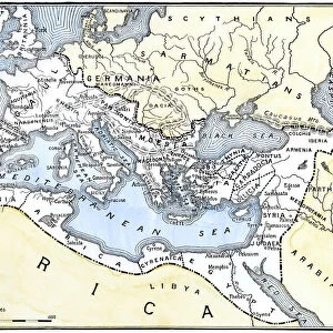
Map of the Roman Empire, 2nd century AD, (1902)
")
![]()
Wall Art and Photo Gifts from Heritage Images
Map of the Roman Empire, 2nd century AD, (1902)
Map of the Roman Empire, 2nd century AD, (1902). Map showing the extent of the Roman Empire about the middle of the 2nd century. Illustration from The Worlds History, The Mediterranean Nations, by Dr H F Helmolt, Volume IV, published by William Heinemann, (London, 1902)
Heritage Images features heritage image collections
Media ID 14913426
© The Print Collector / Heritage-Images
2nd Century Ancient World Atlantic Ocean Dr H F Helmolt H F Helmolt Hans F Hans F Hans Ferdinand Hans Ferdinand Hans Ferdinand Helmolt Helmolt Hf Helmolt Mediterranean Sea Ocean Roman Empire Print Collector4
FEATURES IN THESE COLLECTIONS
> Arts
> Artists
> O
> Oceanic Oceanic
> Arts
> Artists
> R
> Roman Roman
> Europe
> Italy
> Lazio
> Rome
> Historic
> Ancient civilizations
> Roman Empire
> Ancient Rome
> Historic
> Ancient civilizations
> Roman Empire
> Roman art
> Maps and Charts
> Early Maps
> Maps and Charts
> Italy
> Maps and Charts
> Related Images
> Maps and Charts
> World
EDITORS COMMENTS
This print showcases a meticulously detailed "Map of the Roman Empire, 2nd century AD" from 1902. The map, featured in Dr H F Helmolt's renowned book "The Worlds History, The Mediterranean Nations" offers a vivid illustration of the extent and grandeur of the ancient Roman Empire during the middle of the 2nd century. With vibrant colors and intricate cartography, this print takes us back to an era when Rome reigned supreme over vast territories across Europe and beyond. It highlights not only Italy but also various countries and regions that were once under Roman rule. From coastlines to continents, every inch is carefully depicted with accuracy. As we gaze upon this historical gem, it becomes evident how significant the empire was in shaping world history. Its influence extended far beyond its borders as it touched distant lands along the Atlantic Ocean and Mediterranean Sea. The creator of this masterpiece remains unknown; however, their attention to detail captures our imagination and transports us back in time. This print serves as a valuable resource for historians, scholars, or anyone fascinated by ancient Rome or eager to explore our shared human heritage. Preserved through time by Heritage Images' dedication to preserving historical artifacts like these prints without commercial use intentions ensures that future generations can appreciate and learn from them.
MADE IN AUSTRALIA
Safe Shipping with 30 Day Money Back Guarantee
FREE PERSONALISATION*
We are proud to offer a range of customisation features including Personalised Captions, Color Filters and Picture Zoom Tools
SECURE PAYMENTS
We happily accept a wide range of payment options so you can pay for the things you need in the way that is most convenient for you
* Options may vary by product and licensing agreement. Zoomed Pictures can be adjusted in the Cart.