Jigsaw Puzzle > North America > United States of America > Virginia > Hampton
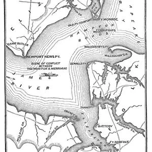
Jigsaw Puzzle : Map of the Battle of Hampton Roads


![]()
Jigsaw Puzzles from Fine Art Storehouse
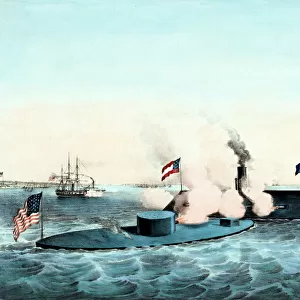
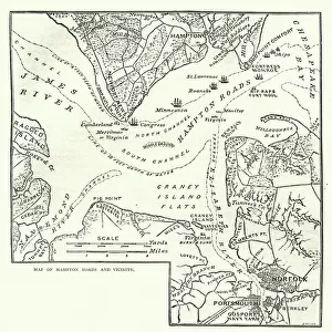
Map of the Battle of Hampton Roads
Vintage engraving of a Map of the Battle of Hampton Roads, often referred to as either the Battle of the Monitor and Merrimack (or Virginia) or the Battle of Ironclads, was the most noted and arguably most important naval battle of the American Civil War
Unleash your creativity and transform your space into a visual masterpiece!
duncan1890
Media ID 14756718
© This content is subject to copyright
Mid Atlantic Usa Paper Based Equipment Battle Of Hampton Roads
Jigsaw Puzzle (500 Pieces)
Discover the thrill of piecing together history with our Media Storehouse Map of the Battle of Hampton Roads jigsaw puzzle. This captivating puzzle features an intricately detailed vintage engraving by duncan1890 from the Fine Art Storehouse. Relive the historic event that took place on March 8-9, 1862, often referred to as the Battle of the Monitor and Merrimack or the Battle of Ironclads. Assemble this beautiful puzzle to bring the tactical layout of the battle, complete with ships and strategic positions, to life in your home. Immerse yourself in history and test your problem-solving skills with this challenging and educational puzzle.
500 piece puzzles are custom made in Australia and hand-finished on 100% recycled 1.6mm thick laminated puzzle boards. There is a level of repetition in jigsaw shapes with each matching piece away from its pair. The completed puzzle measures 40x51cm and is delivered packaged in an attractive presentation box specially designed to fit most mail slots with a unique magnetic lid
Jigsaw Puzzles are an ideal gift for any occasion
Estimated Product Size is 40.3cm x 50.7cm (15.9" x 20")
These are individually made so all sizes are approximate
Artwork printed orientated as per the preview above, with landscape (horizontal) or portrait (vertical) orientation to match the source image.
FEATURES IN THESE COLLECTIONS
> Fine Art Storehouse
> History
> Battles & Wars
> American Civil War (1860-1865)
> Fine Art Storehouse
> History
> Battles & Wars
> Historcal Battle Maps and Plans
> Fine Art Storehouse
> Map
> Historical Maps
> Fine Art Storehouse
> Map
> USA Maps
> Historic
> Battles
> Related Images
> Maps and Charts
> Related Images
> North America
> United States of America
> Maps
> North America
> United States of America
> Virginia
> Hampton
> North America
> United States of America
> Virginia
> Related Images
EDITORS COMMENTS
This vintage engraving of the Map of the Battle of Hampton Roads takes us back to a pivotal moment in American history. The battle, also known as the Battle of the Monitor and Merrimack or Virginia, was a groundbreaking naval encounter during the American Civil War. This print beautifully captures the essence of this historic event. The image showcases intricate details that bring to life the mid-Atlantic region where this epic clash took place. With paper-based equipment at their disposal, both sides engaged in an intense struggle for dominance on these very waters. The map highlights strategic positions and maneuvers undertaken by each vessel involved, providing a comprehensive overview of this significant engagement. Considered one of the most important naval battles in American history, it forever changed warfare tactics with its introduction of ironclad warships. As we gaze upon this remarkable piece, we are reminded not only of its historical significance but also its artistic value. Duncan1890's masterful reproduction allows us to appreciate every line and contour meticulously etched into this print. It serves as a testament to his dedication in preserving such crucial moments from our past through artistry. Whether you are an avid historian or simply captivated by stunning artwork, this Map of the Battle of Hampton Roads is sure to ignite your imagination and transport you back to a time when two iron behemoths clashed amidst swirling currents and billowing smoke.
MADE IN AUSTRALIA
Safe Shipping with 30 Day Money Back Guarantee
FREE PERSONALISATION*
We are proud to offer a range of customisation features including Personalised Captions, Color Filters and Picture Zoom Tools
SECURE PAYMENTS
We happily accept a wide range of payment options so you can pay for the things you need in the way that is most convenient for you
* Options may vary by product and licensing agreement. Zoomed Pictures can be adjusted in the Cart.