Jigsaw Puzzle > Fine Art Storehouse > Map
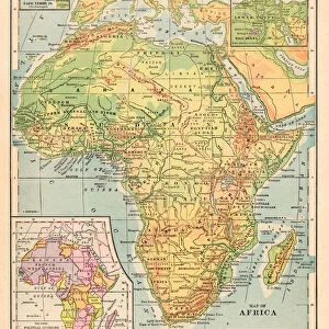
Jigsaw Puzzle : Map of Africa 1869


![]()
Jigsaw Puzzles from Fine Art Storehouse
Map of Africa 1869
Cornells Grammars-School Geography - S.S. Cornell - New York D. Appleton and Company 1869
Unleash your creativity and transform your space into a visual masterpiece!
THEPALMER
Media ID 13668853
© Roberto A Sanchez
Egypt Ethiopia Horn Of Africa Indian Ocean Middle East Obsolete
Jigsaw Puzzle (500 Pieces)
Discover the rich history of geography with our Media Storehouse Map of Africa 1869 jigsaw puzzle, featuring the intricate and detailed work of THEPALMER from the Fine Art Storehouse. This captivating puzzle, inspired by a map published by S.S. Cornell - New York D. Appleton and Company in 1869, offers an educational and engaging puzzle experience for all ages. Immerse yourself in the exploration and discovery of Africa's diverse landscapes and political boundaries as they appeared over 150 years ago. Bring history to life, one piece at a time.
500 piece puzzles are custom made in Australia and hand-finished on 100% recycled 1.6mm thick laminated puzzle boards. There is a level of repetition in jigsaw shapes with each matching piece away from its pair. The completed puzzle measures 40x51cm and is delivered packaged in an attractive presentation box specially designed to fit most mail slots with a unique magnetic lid
Jigsaw Puzzles are an ideal gift for any occasion
Estimated Product Size is 40.3cm x 50.7cm (15.9" x 20")
These are individually made so all sizes are approximate
Artwork printed orientated as per the preview above, with landscape (horizontal) or portrait (vertical) orientation to match the source image.
FEATURES IN THESE COLLECTIONS
> Fine Art Storehouse
> The Magical World of Illustration
> Palmer Illustrated Collection
> Fine Art Storehouse
> Map
> Historical Maps
EDITORS COMMENTS
This print showcases a remarkable piece of cartographic history - the "Map of Africa 1869" from Cornells Grammars-School Geography. A product of its time, this engraved image transports us back to an era when physical geography was still being explored and understood. The intricate details and delicate engravings on this map offer a glimpse into the world as it was perceived in the late 19th century. Spanning across the vertical frame, we can trace our eyes over vast stretches of land and water, exploring the diverse regions that make up Africa. From Ethiopia to Egypt, every country is meticulously outlined with precision and care. The Indian Ocean glistens in vibrant blue hues, reminding us of its importance as a trade route connecting continents. The Middle East and Horn of Africa are also prominently featured, highlighting their significance in both historical context and contemporary geopolitics. This illustration serves as a visual testament to how borders have shifted over time while capturing the essence of African geography during this period. As we admire this antique masterpiece by THEPALMER from Fine Art Storehouse, we are reminded not only of its aesthetic value but also its educational significance. It invites us to reflect on how our understanding of maps has evolved throughout history while appreciating the artistry involved in creating such detailed engravings.
MADE IN AUSTRALIA
Safe Shipping with 30 Day Money Back Guarantee
FREE PERSONALISATION*
We are proud to offer a range of customisation features including Personalised Captions, Color Filters and Picture Zoom Tools
SECURE PAYMENTS
We happily accept a wide range of payment options so you can pay for the things you need in the way that is most convenient for you
* Options may vary by product and licensing agreement. Zoomed Pictures can be adjusted in the Cart.