Jigsaw Puzzle > Europe > Hungary > Maps
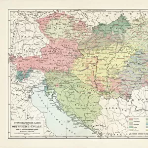
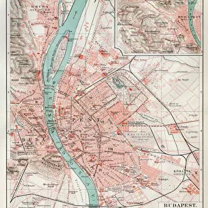
Jigsaw Puzzle : Map of Austro-Hungarian monarchy 1889


![]()
Jigsaw Puzzles from Fine Art Storehouse
Map of Austro-Hungarian monarchy 1889
Comprehensive Geography by James Monteith - American Book Company 1882, 1889
Unleash your creativity and transform your space into a visual masterpiece!
THEPALMER
Media ID 18357305
Jigsaw Puzzle (500 Pieces)
Discover history with the Media Storehouse Jigsaw Puzzle of "Map of Austro-Hungarian Monarchy 1889" by THEPALMER from Fine Art Storehouse. This intricately detailed puzzle, inspired by a map from Comprehensive Geography by James Monteith published by the American Book Company in 1882 and 1889, invites you on a journey back in time. With each piece placed, you'll uncover the intricate borders and territories of the Austro-Hungarian Empire in its prime. Challenge yourself with this historical puzzle and bring a piece of the past into your home.
500 piece puzzles are custom made in Australia and hand-finished on 100% recycled 1.6mm thick laminated puzzle boards. There is a level of repetition in jigsaw shapes with each matching piece away from its pair. The completed puzzle measures 40x51cm and is delivered packaged in an attractive presentation box specially designed to fit most mail slots with a unique magnetic lid
Jigsaw Puzzles are an ideal gift for any occasion
Estimated Product Size is 50.7cm x 40.3cm (20" x 15.9")
These are individually made so all sizes are approximate
Artwork printed orientated as per the preview above, with landscape (horizontal) or portrait (vertical) orientation to match the source image.
FEATURES IN THESE COLLECTIONS
> Fine Art Storehouse
> Map
> Historical Maps
> Europe
> Hungary
> Related Images
> Maps and Charts
> Related Images
EDITORS COMMENTS
In this print titled "Map of Austro-Hungarian Monarchy 1889" we are transported back in time to the late 19th century, where the intricate details of a bygone era unfold before our eyes. The map, sourced from James Monteith's Comprehensive Geography published in 1882 and updated in 1889, serves as a testament to both historical accuracy and artistic craftsmanship. The vast Austro-Hungarian Monarchy sprawls across the image, showcasing its immense territorial reach that once dominated Central Europe. Every contour and boundary line is meticulously etched onto the paper, revealing an empire rich in diversity and cultural heritage. From Vienna's grandeur to Budapest's architectural marvels, this map encapsulates the essence of a powerful union that thrived during its existence. As we delve deeper into this visual treasure trove curated by THEPALMER for Fine Art Storehouse, it becomes evident that this piece holds more than just geographical significance. It acts as a portal through time—an invitation to explore an era when empires reigned supreme and borders were fluid yet fiercely guarded. Whether you are an avid historian or simply captivated by vintage cartography, "Map of Austro-Hungarian Monarchy 1889" offers a glimpse into a world long past but forever imprinted on these delicate lines. Let your imagination wander amidst these faded colors and forgotten names; let history come alive within your grasp as you embark on a journey through one of Europe's most influential
MADE IN AUSTRALIA
Safe Shipping with 30 Day Money Back Guarantee
FREE PERSONALISATION*
We are proud to offer a range of customisation features including Personalised Captions, Color Filters and Picture Zoom Tools
SECURE PAYMENTS
We happily accept a wide range of payment options so you can pay for the things you need in the way that is most convenient for you
* Options may vary by product and licensing agreement. Zoomed Pictures can be adjusted in the Cart.