Jigsaw Puzzle > North America > United States of America > Michigan > Warren
Jigsaw Puzzle : Map of Central states 1877


![]()
Jigsaw Puzzles from Fine Art Storehouse
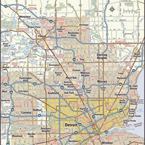
Map of Central states 1877
Warrens Common School Geography 1877
Unleash your creativity and transform your space into a visual masterpiece!
THEPALMER
Media ID 14824565
© This content is subject to copyright
Illinois Indiana Kentucky Michigan Ohio Wisconsin
Jigsaw Puzzle (500 Pieces)
Discover the rich history of American geography with our captivating jigsaw puzzle from Media Storehouse, featuring the intricately detailed "Map of Central States 1877" by THEPALMER from Fine Art Storehouse. This vintage map, originally published in Warren's Common School Geography of 1877, invites you on a journey back in time as you piece together the history of the Central States. With authentic cartography and stunning attention to detail, this jigsaw puzzle is not only a fun and engaging activity for all ages, but also a beautiful addition to any home or office. Perfect for puzzle enthusiasts, history buffs, or anyone looking to expand their knowledge and appreciation for the history of cartography. Get ready to embark on an educational and enjoyable adventure with Media Storehouse's Map of Central States 1877 jigsaw puzzle.
500 piece puzzles are custom made in Australia and hand-finished on 100% recycled 1.6mm thick laminated puzzle boards. There is a level of repetition in jigsaw shapes with each matching piece away from its pair. The completed puzzle measures 40x51cm and is delivered packaged in an attractive presentation box specially designed to fit most mail slots with a unique magnetic lid
Jigsaw Puzzles are an ideal gift for any occasion
Estimated Product Size is 40.3cm x 50.7cm (15.9" x 20")
These are individually made so all sizes are approximate
Artwork printed orientated as per the preview above, with landscape (horizontal) or portrait (vertical) orientation to match the source image.
FEATURES IN THESE COLLECTIONS
> Fine Art Storehouse
> Map
> Historical Maps
> Maps and Charts
> Related Images
> North America
> United States of America
> Michigan
> Warren
EDITORS COMMENTS
In this print titled "Map of Central states 1877" we are transported back in time to the late 19th century, when cartography was a meticulous art form. Taken from Warren's Common School Geography published in 1877, this piece offers us a glimpse into the geographical landscape of central states such as Illinois, Indiana, Kentucky, Michigan, Ohio, and Wisconsin. The map itself is an intricate tapestry of vibrant colors and precise details that showcase the craftsmanship of its creator. Each state is meticulously outlined with delicate strokes and labeled with elegant typography. From the majestic Great Lakes bordering Michigan to the winding rivers that carve through these states' heartlands, every feature on this map tells a story of exploration and settlement. As we delve deeper into this historical artifact by THEPALMER from Fine Art Storehouse, it becomes apparent that it serves not only as a navigational tool but also as a window into America's past. It allows us to trace the footsteps of pioneers who ventured westward during times of great expansion and change. Whether you have an affinity for history or simply appreciate fine artistry, "Map of Central states 1877" transports you to another era where maps were cherished possessions guiding individuals through uncharted territories. This print captures both our curiosity about the world around us and our desire to preserve moments frozen in time.
MADE IN AUSTRALIA
Safe Shipping with 30 Day Money Back Guarantee
FREE PERSONALISATION*
We are proud to offer a range of customisation features including Personalised Captions, Color Filters and Picture Zoom Tools
SECURE PAYMENTS
We happily accept a wide range of payment options so you can pay for the things you need in the way that is most convenient for you
* Options may vary by product and licensing agreement. Zoomed Pictures can be adjusted in the Cart.


![St Pauls Station - Second and Third Floor Plans Restaurant Annex [1923]](/sq/229/st-pauls-station-second-floor-plans-restaurant-19192079.jpg.webp)