Jigsaw Puzzle > North America > United States of America > New York > New York > Maps
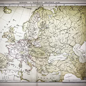
Jigsaw Puzzle : Map of Europe in the time of Napoleon I 1881


![]()
Jigsaw Puzzles from Fine Art Storehouse
Map of Europe in the time of Napoleon I 1881
Appletons American Standard Geographies - New York 1881 - d. Appleton and Company
Unleash your creativity and transform your space into a visual masterpiece!
THEPALMER
Media ID 18442883
© 2014 Roberto Adrian Photography
Jigsaw Puzzle (1000 Pieces)
Discover the intrigue of history with our exquisite jigsaw puzzle from Media Storehouse - "Map of Europe in the Time of Napoleon I 1881" by THEPALMER from Fine Art Storehouse. This captivating puzzle, inspired by the Appleton's American Standard Geographies published by Appleton and Company in 1881, invites you on a journey back in time. Immerse yourself in the intricate details of European borders and territories as they existed during the reign of Napoleon I. With rich, authentic colors and meticulously detailed illustrations, this puzzle is not only an enjoyable challenge but also an educational experience. Bring history to life in your own home and create a stunning display piece with this fascinating jigsaw puzzle.
1000 piece puzzles are custom made in Australia and hand-finished on 100% recycled 1.6mm thick laminated puzzle boards. There is a level of repetition in jigsaw shapes with each matching piece away from its pair. The completed puzzle measures 76x50cm and is delivered packaged in an attractive presentation box specially designed to fit most mail slots with a unique magnetic lid
Jigsaw Puzzles are an ideal gift for any occasion
Estimated Product Size is 76cm x 50.2cm (29.9" x 19.8")
These are individually made so all sizes are approximate
Artwork printed orientated as per the preview above, with landscape (horizontal) or portrait (vertical) orientation to match the source image.
FEATURES IN THESE COLLECTIONS
> Fine Art Storehouse
> Map
> Historical Maps
> Europe
> Related Images
> Maps and Charts
> Related Images
> North America
> United States of America
> New York
> New York
> Maps
> North America
> United States of America
> New York
> Related Images
EDITORS COMMENTS
In this print titled "Map of Europe in the time of Napoleon I 1881" we are transported back to a pivotal era in European history. The image, sourced from Appletons American Standard Geographies - New York 1881 by d. Appleton and Company, offers a glimpse into the geopolitical landscape during the reign of Napoleon Bonaparte. The map itself is a testament to both artistry and historical accuracy, showcasing intricate details that bring the past to life. As our eyes wander across its surface, we can trace the borders of various nations as they existed at that time – France under Napoleon's rule dominating much of continental Europe, while other powers such as Britain, Austria, Prussia, and Russia jostle for their own spheres of influence. This particular print captures not only an important moment in European history but also serves as a reminder of how cartography has evolved over time. It showcases the craftsmanship involved in creating detailed maps before modern technology made it more accessible. "The Map of Europe in the time of Napoleon I" invites us to reflect on how political boundaries have shifted throughout history and encourages us to delve deeper into understanding this transformative period. Its presence adds depth and character to any space it graces while serving as a visual gateway into an intriguing chapter from our collective past.
MADE IN AUSTRALIA
Safe Shipping with 30 Day Money Back Guarantee
FREE PERSONALISATION*
We are proud to offer a range of customisation features including Personalised Captions, Color Filters and Picture Zoom Tools
SECURE PAYMENTS
We happily accept a wide range of payment options so you can pay for the things you need in the way that is most convenient for you
* Options may vary by product and licensing agreement. Zoomed Pictures can be adjusted in the Cart.