Jigsaw Puzzle > North America > United States of America > New York > New York > Maps
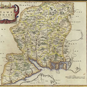
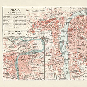
Jigsaw Puzzle : Map of Hampshire 1883


![]()
Jigsaw Puzzles from Fine Art Storehouse
Map of Hampshire 1883
Encyclopedia Britannica 9th Edition New York Samuel L. Hall 1883 Vol XI
Unleash your creativity and transform your space into a visual masterpiece!
THEPALMER
Media ID 14549453
© This content is subject to copyright
Jigsaw Puzzle (500 Pieces)
Discover the captivating world of yesteryears with our exquisite "Map of Hampshire 1883" jigsaw puzzle from ThePalmer at Media Storehouse's Fine Art Storehouse. This intriguing puzzle, inspired by the Encyclopedia Britannica 9th Edition New York Samuel L. Hall 1883 Vol XI, invites you on a journey back in time. Explore the historical details and intricate cartography of Hampshire County, England, as it appeared over a century ago. Piece together this vibrant and educational puzzle, perfect for puzzle enthusiasts, history buffs, or anyone seeking a fun and engaging activity. Immerse yourself in the rich history and beauty of the past with Media Storehouse's Map of Hampshire 1883 jigsaw puzzle.
500 piece puzzles are custom made in Australia and hand-finished on 100% recycled 1.6mm thick laminated puzzle boards. There is a level of repetition in jigsaw shapes with each matching piece away from its pair. The completed puzzle measures 40x51cm and is delivered packaged in an attractive presentation box specially designed to fit most mail slots with a unique magnetic lid
Jigsaw Puzzles are an ideal gift for any occasion
Estimated Product Size is 40.3cm x 50.7cm (15.9" x 20")
These are individually made so all sizes are approximate
Artwork printed orientated as per the preview above, with landscape (horizontal) or portrait (vertical) orientation to match the source image.
FEATURES IN THESE COLLECTIONS
> Fine Art Storehouse
> Map
> Historical Maps
> Europe
> United Kingdom
> England
> Hampshire
> Related Images
> Europe
> United Kingdom
> England
> Maps
> Europe
> United Kingdom
> England
> Posters
> Europe
> United Kingdom
> England
> Related Images
> Europe
> United Kingdom
> England
> York
> Europe
> United Kingdom
> Maps
> Maps and Charts
> Related Images
> North America
> United States of America
> New York
> New York
> Maps
> North America
> United States of America
> New York
> Related Images
EDITORS COMMENTS
This print showcases a remarkable piece of history, the "Map of Hampshire 1883". Taken from the Encyclopedia Britannica's 9th Edition, this vintage map transports us back to a bygone era. Created in New York by Samuel L. Hall in 1883, it is an exquisite representation of Hampshire County in England. The intricate details and delicate craftsmanship captured within this print are truly awe-inspiring. Every contour and boundary line has been meticulously drawn, offering a glimpse into the geographical landscape as it existed over a century ago. The fine artistry displayed here is a testament to both the skill of its creator and the importance placed on cartography during that time. As we gaze upon this historical treasure, our imagination takes flight. We envision bustling towns and serene countryside scenes that once dotted this picturesque county. It serves as a reminder of how much has changed since then while also evoking nostalgia for simpler times. "The Map of Hampshire 1883" offers more than just geographic information; it encapsulates an entire era's spirit and charm within its inked lines. This print by THEPALMER allows us to bring home a piece of history and appreciate the beauty found in antique maps like never before.
MADE IN AUSTRALIA
Safe Shipping with 30 Day Money Back Guarantee
FREE PERSONALISATION*
We are proud to offer a range of customisation features including Personalised Captions, Color Filters and Picture Zoom Tools
SECURE PAYMENTS
We happily accept a wide range of payment options so you can pay for the things you need in the way that is most convenient for you
* Options may vary by product and licensing agreement. Zoomed Pictures can be adjusted in the Cart.