Jigsaw Puzzle > Arts > Artists > B > Augustus Butler
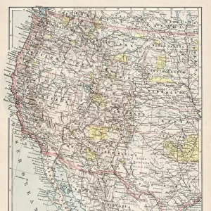
Jigsaw Puzzle : Map of Western states 1881


![]()
Jigsaw Puzzles from Fine Art Storehouse
Map of Western states 1881
A System of Modern Geography designed for the use of schools and academies by Augustus Mitchell - Published by T. H. Butler / Philadelphia 1881
Unleash your creativity and transform your space into a visual masterpiece!
THEPALMER
Media ID 18357229
Jigsaw Puzzle (500 Pieces)
Discover the history of Western exploration with our captivating jigsaw puzzle from Media Storehouse. This intricately detailed puzzle features the "Map of Western States 1881" by THEPALMER from the Fine Art Storehouse. A treasure from the "A System of Modern Geography" published by T. H. Butler in Philadelphia, this puzzle invites you on a journey back in time. Piece together this historic map of the Western United States from 1881, revealing intricate borders, topography, and early settlements. Ideal for history enthusiasts, educators, or anyone seeking a challenging puzzle experience, this puzzle is a must-have for your collection.
500 piece puzzles are custom made in Australia and hand-finished on 100% recycled 1.6mm thick laminated puzzle boards. There is a level of repetition in jigsaw shapes with each matching piece away from its pair. The completed puzzle measures 40x51cm and is delivered packaged in an attractive presentation box specially designed to fit most mail slots with a unique magnetic lid
Jigsaw Puzzles are an ideal gift for any occasion
Estimated Product Size is 50.7cm x 40.3cm (20" x 15.9")
These are individually made so all sizes are approximate
Artwork printed orientated as per the preview above, with landscape (horizontal) or portrait (vertical) orientation to match the source image.
FEATURES IN THESE COLLECTIONS
> Fine Art Storehouse
> Map
> Historical Maps
> Animals
> Mammals
> Muridae
> Western Mouse
> Arts
> Artists
> B
> Augustus Butler
> Maps and Charts
> Related Images
EDITORS COMMENTS
This print showcases a remarkable piece of history, the "Map of Western states 1881". Created by Augustus Mitchell and published in Philadelphia back in 1881, this map was specifically designed for educational purposes within schools and academies. The level of detail captured in this print is truly awe-inspiring, as it provides an invaluable glimpse into the geographical knowledge of that era. The Map of Western states 1881 depicts a vast expanse encompassing various western regions during a time when exploration and settlement were rapidly shaping the American landscape. From majestic mountain ranges to winding rivers, from sprawling plains to bustling cities, every intricate feature has been meticulously illustrated on this vintage map. It serves as both an educational tool and a testament to the pioneering spirit that defined America's westward expansion. Preserved with utmost care by THEPALMER at Fine Art Storehouse, this print allows us to travel back in time and immerse ourselves in the rich history it represents. Whether you are an avid collector or simply appreciate historical artifacts, this extraordinary piece will undoubtedly spark curiosity and ignite conversations about our nation's past. Displaying the Map of Western states 1881 proudly on your wall not only adds aesthetic value but also serves as a reminder of how far we have come since those early days. Let its timeless beauty transport you to an era where discovery knew no bounds – an era forever etched onto this magnificent work by Augustus Mitchell.
MADE IN AUSTRALIA
Safe Shipping with 30 Day Money Back Guarantee
FREE PERSONALISATION*
We are proud to offer a range of customisation features including Personalised Captions, Color Filters and Picture Zoom Tools
SECURE PAYMENTS
We happily accept a wide range of payment options so you can pay for the things you need in the way that is most convenient for you
* Options may vary by product and licensing agreement. Zoomed Pictures can be adjusted in the Cart.