Jigsaw Puzzle > North America > United States of America > New York > New York > Maps
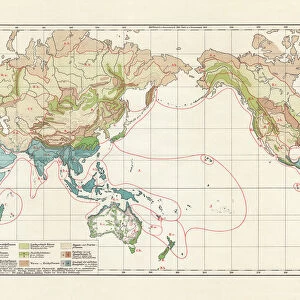
Jigsaw Puzzle : Map of the world 1895


![]()
Jigsaw Puzzles from Fine Art Storehouse
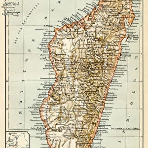
Map of the world 1895
The Rand-McNally Grammar School Geography 1895 - Chicago & New York
Unleash your creativity and transform your space into a visual masterpiece!
THEPALMER
Media ID 14824605
© This content is subject to copyright
Jigsaw Puzzle (1000 Pieces)
Discover the wonders of the past with Media Storehouse's Jigsaw Puzzle collection, featuring the captivating "Map of the World 1895" by THEPALMER from Fine Art Storehouse. This intriguing puzzle brings history to life, showcasing the world as it appeared in 1895 according to the Rand-McNally Grammar School Geography of Chicago & New York. Engage in a stimulating and educational experience as you piece together this vintage map, revealing fascinating insights into the geography and political landscape of the late 19th century. Perfect for history enthusiasts, puzzle lovers, or anyone seeking a captivating pastime, this jigsaw puzzle is a must-have addition to your collection.
1000 piece puzzles are custom made in Australia and hand-finished on 100% recycled 1.6mm thick laminated puzzle boards. There is a level of repetition in jigsaw shapes with each matching piece away from its pair. The completed puzzle measures 76x50cm and is delivered packaged in an attractive presentation box specially designed to fit most mail slots with a unique magnetic lid
Jigsaw Puzzles are an ideal gift for any occasion
Estimated Product Size is 76cm x 50.2cm (29.9" x 19.8")
These are individually made so all sizes are approximate
Artwork printed orientated as per the preview above, with landscape (horizontal) or portrait (vertical) orientation to match the source image.
FEATURES IN THESE COLLECTIONS
> Fine Art Storehouse
> Map
> Historical Maps
> Maps and Charts
> Related Images
> Maps and Charts
> World
> North America
> United States of America
> New York
> New York
> Maps
> North America
> United States of America
> New York
> Related Images
EDITORS COMMENTS
In this print titled "Map of the World 1895" we are transported back in time to a bygone era when cartography was both an art form and a scientific endeavor. The map, originally published in "The Rand-McNally Grammar School Geography 1895" in Chicago and New York, exudes an air of nostalgia and curiosity. As our eyes wander across the intricate details of this vintage masterpiece, we are reminded of the vastness and diversity that our planet holds. Every contour, every line represents not only geographical boundaries but also stories waiting to be discovered. It is as if each country has its own unique personality, inviting us to embark on a journey through time. The craftsmanship evident in this print is truly remarkable; it reflects the meticulous efforts put forth by early cartographers who painstakingly documented every inch of landmass with precision. The faded colors add a touch of antiquity, reminding us that maps like these were once treasured possessions used for exploration or educational purposes. "The Map of the World 1895" transports us beyond mere geography; it evokes a sense of wonderment about how much our world has changed since then. It serves as a reminder that while borders may shift over time, our shared humanity remains constant. This Fine Art Storehouse print by THEPALMER allows us to bring home a piece of history – an exquisite snapshot frozen in time – igniting conversations about past adventures and inspiring future explorations.
MADE IN AUSTRALIA
Safe Shipping with 30 Day Money Back Guarantee
FREE PERSONALISATION*
We are proud to offer a range of customisation features including Personalised Captions, Color Filters and Picture Zoom Tools
SECURE PAYMENTS
We happily accept a wide range of payment options so you can pay for the things you need in the way that is most convenient for you
* Options may vary by product and licensing agreement. Zoomed Pictures can be adjusted in the Cart.