Jigsaw Puzzle > Arts > Photorealistic artworks > Detailed art pieces > Masterful detailing in art
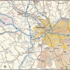
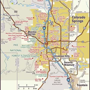
Jigsaw Puzzle : Ohio Map. A detailed map of Ohio state with cities, roads, major rivers,


![]()
Jigsaw Puzzles From Fine Art Storehouse
Ohio Map. A detailed map of Ohio state with cities, roads, major rivers,
A detailed map of Ohio state with cities, roads, major rivers, and lakes plus National Forests. Includes neighboring states and surrounding water
Unleash your creativity and transform your space into a visual masterpiece!
Media ID 15495539
Jigsaw Puzzle (500 Pieces)
Discover the beauty and complexity of the Midwest with our Ohio Map Jigsaw Puzzle from the Media Storehouse Fine Art Collection. This intricately detailed puzzle showcases a stunning representation of the Ohio state map, featuring cities, major roads, rivers, and lakes. Explore the major landmarks, including the Great Lakes and neighboring states, all while immersing yourself in the rich tapestry of American geography. Perfect for puzzle enthusiasts and history buffs alike, this Ohio Map puzzle offers hours of engaging entertainment and a beautiful addition to any home or office. Bring the wonders of Ohio right to your living room with the Media Storehouse Ohio Map Jigsaw Puzzle from Fine Art Storehouse.
500 piece puzzles are custom made in Australia and hand-finished on 100% recycled 1.6mm thick laminated puzzle boards. There is a level of repetition in jigsaw shapes with each matching piece away from its pair. The completed puzzle measures 40x51cm and is delivered packaged in an attractive presentation box specially designed to fit most mail slots with a unique magnetic lid
Jigsaw Puzzles are an ideal gift for any occasion
Estimated Product Size is 50.7cm x 40.3cm (20" x 15.9")
These are individually made so all sizes are approximate
Artwork printed orientated as per the preview above, with landscape (horizontal) or portrait (vertical) orientation to match the source image.
FEATURES IN THESE COLLECTIONS
> Fine Art Storehouse
> Map
> Reference Maps
> Arts
> Landscape paintings
> Forest and woodland scenes
> Forest artwork
> Arts
> Photorealistic artworks
> Detailed art pieces
> Masterful detailing in art
> Maps and Charts
> Related Images
EDITORS COMMENTS
This print showcases the intricate beauty of Ohio, a state brimming with rich history and natural wonders. The detailed map offers an immersive exploration of the Buckeye State, highlighting its cities, roads, major rivers, lakes, as well as the sprawling National Forests that dot its landscape. From bustling urban centers like Columbus and Cleveland to charming towns nestled amidst picturesque countryside, this map encapsulates the diverse tapestry of Ohio's communities. Each city is marked with precision, inviting viewers to embark on a virtual journey through this vibrant state. The inclusion of neighboring states and surrounding water provides context to Ohio's geographical location within the United States. It serves as a reminder that while Ohio stands proudly on its own merits, it is also part of a larger interconnected region. Beyond serving as a navigational tool or educational resource for geography enthusiasts, this print transcends utility by capturing the essence and allure of Ohio's topography. Its vivid colors breathe life into every contour and landmark depicted on the map. Whether displayed in homes or offices alike, this Fine Art Storehouse print invites viewers to appreciate both the artistry behind cartography and the inherent beauty found within our earthly landscapes. It celebrates not only Ohio but also ignites curiosity about other regions waiting to be explored beyond its borders.
MADE IN AUSTRALIA
Safe Shipping with 30 Day Money Back Guarantee
FREE PERSONALISATION*
We are proud to offer a range of customisation features including Personalised Captions, Color Filters and Picture Zoom Tools
SECURE PAYMENTS
We happily accept a wide range of payment options so you can pay for the things you need in the way that is most convenient for you
* Options may vary by product and licensing agreement. Zoomed Pictures can be adjusted in the Basket.