Jigsaw Puzzle > North America > United States of America > Maps
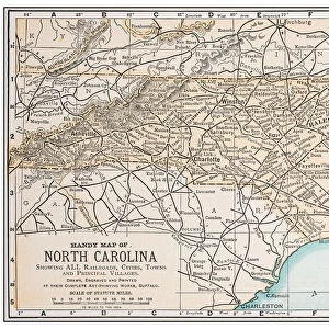
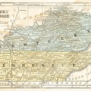
Jigsaw Puzzle : North Carolina USA map 1898


![]()
Jigsaw Puzzles from Fine Art Storehouse
North Carolina USA map 1898
Map from the Complete Handy Atlas of the World - 1898
Unleash your creativity and transform your space into a visual masterpiece!
THEPALMER
Media ID 20114755
© A 2014 Roberto Adrian Photography
Jigsaw Puzzle (1000 Pieces)
Discover the rich history of North Carolina with our captivating jigsaw puzzle from Media Storehouse. This intricately detailed puzzle, featuring the North Carolina map from the Complete Handy Atlas of the World (1898) by THEPALMER from Fine Art Storehouse, offers a fun and engaging way to explore the Old North State's geography. Immerse yourself in the intricacies of the puzzle pieces and uncover the beauty of this vintage map, transporting you back in time. Perfect for puzzle enthusiasts, history buffs, or anyone seeking a challenging and rewarding pastime.
1000 piece puzzles are custom made in Australia and hand-finished on 100% recycled 1.6mm thick laminated puzzle boards. There is a level of repetition in jigsaw shapes with each matching piece away from its pair. The completed puzzle measures 76x50cm and is delivered packaged in an attractive presentation box specially designed to fit most mail slots with a unique magnetic lid
Jigsaw Puzzles are an ideal gift for any occasion
Estimated Product Size is 76cm x 50.2cm (29.9" x 19.8")
These are individually made so all sizes are approximate
Artwork printed orientated as per the preview above, with landscape (horizontal) or portrait (vertical) orientation to match the source image.
FEATURES IN THESE COLLECTIONS
> Fine Art Storehouse
> Map
> Historical Maps
> Fine Art Storehouse
> Map
> USA Maps
> Maps and Charts
> Related Images
> Maps and Charts
> World
> North America
> United States of America
> Maps
> North America
> United States of America
> North Carolina
> Related Images
EDITORS COMMENTS
This print showcases a vintage map of North Carolina, USA, dating back to the year 1898. Taken from the renowned "Complete Handy Atlas of the World - 1898" this piece offers a fascinating glimpse into the state's historical geography. The intricate details and exquisite craftsmanship of this map are beautifully preserved in this high-quality print by THEPALMER, available exclusively at Fine Art Storehouse. As we gaze upon this snapshot from the past, we are transported to an era when cartography was both an art form and a scientific endeavor. Every contour line, river bend, and city dot on this meticulously drawn map tells a story of exploration and discovery. It invites us to imagine what life was like in North Carolina over a century ago – its bustling cities, vast farmlands, and untamed wilderness. The sepia tones lend an air of nostalgia to the image while enhancing its antique charm. This stunning print is perfect for history enthusiasts or anyone with an appreciation for vintage aesthetics. Whether displayed in your home or office space, it will undoubtedly spark conversations about North Carolina's rich heritage and serve as a reminder of how much our world has evolved since that time. Immerse yourself in history with this remarkable print capturing North Carolina's essence as it stood proudly on maps more than 120 years ago.
MADE IN AUSTRALIA
Safe Shipping with 30 Day Money Back Guarantee
FREE PERSONALISATION*
We are proud to offer a range of customisation features including Personalised Captions, Color Filters and Picture Zoom Tools
SECURE PAYMENTS
We happily accept a wide range of payment options so you can pay for the things you need in the way that is most convenient for you
* Options may vary by product and licensing agreement. Zoomed Pictures can be adjusted in the Cart.