
San Andreas Fault Collection
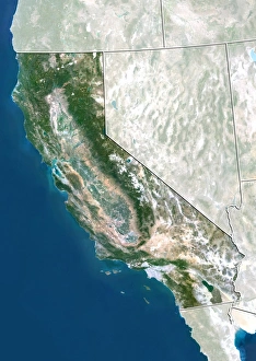
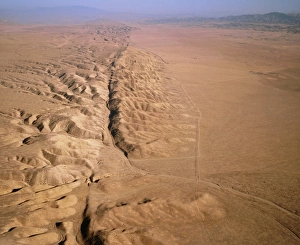
"The San Andreas Fault: Unveiling Earth's Tectonic Power" In this captivating aerial view, we witness the mighty force that lies beneath our feet - the San Andreas Fault


All Professionally Made to Order for Quick Shipping
"The San Andreas Fault: Unveiling Earth's Tectonic Power" In this captivating aerial view, we witness the mighty force that lies beneath our feet - the San Andreas Fault. Stretching over 800 miles along California, this geological marvel marks the boundary between two of Earth's tectonic plates. The haunting remnants of a shattered city come into focus as we delve deeper into history. The ruin of San Francisco serves as a somber reminder of nature's unpredictable might. Its seismographic record even reached far across the Atlantic to leave its mark on the British Isles. The aftermath of the devastating 1906 earthquake is etched in black and white photographs, revealing shattered palaces and crumbling structures. Amongst these ruins stands a solitary tall building, defiantly surviving amidst its fallen neighbors. One lithograph transports us back to an inferno that consumed one of the world's grandest hotels - the Palace Hotel on Market Street. It was from this burning building that opera legend Caruso and his company miraculously escaped. City Hall itself became a symbol of resilience after being reduced to rubble by Mother Nature's wrath. Yet, color lithographs vividly portray both its destruction and eventual reconstruction following the catastrophic earthquake. These images depict not only devastation but also humanity's indomitable spirit in rebuilding what was lost. They capture moments frozen in time when great disasters forever altered San Francisco’s landscape. As we gaze upon panoramic views showcasing vast stretches of ruins left behind by that fateful tremor, we are reminded once again how fragile our existence can be in face of such seismic forces.