Jigsaw Puzzle > Europe > United Kingdom > Scotland > Edinburgh > Edinburgh
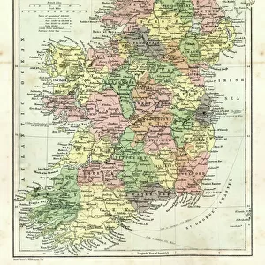
Jigsaw Puzzle : Map of Ireland, 1902. Creator: Unknown


![]()
Jigsaw Puzzles from Heritage Images
Map of Ireland, 1902. Creator: Unknown
Map of Ireland, 1902. Showing the island of Ireland before the partition of the six counties which became Northern Ireland, with insets showing Dublin and Belfast. From The Century Atlas of the World. [John Walker & Co, Ltd. London, 1902]
Heritage Images features heritage image collections
Media ID 15512570
© The Print Collector / Heritage-Images
Belfast Counties County County Dublin Dublin Edinburgh Geographical Institute Eire Ireland Northern Ireland
Jigsaw Puzzle (500 Pieces)
Discover the history of Ireland with our captivating jigsaw puzzle from Media Storehouse. This intriguing puzzle features an authentic map of Ireland from 1902, showcasing the island before the partition of the six counties that later became Northern Ireland. Delve into the rich heritage of this historic map, which includes detailed insets of Dublin and Belfast. Piece together this fascinating puzzle and transport yourself back in time, making it a perfect addition to your collection for history enthusiasts and puzzle lovers alike.
500 piece puzzles are custom made in Australia and hand-finished on 100% recycled 1.6mm thick laminated puzzle boards. There is a level of repetition in jigsaw shapes with each matching piece away from its pair. The completed puzzle measures 40x51cm and is delivered packaged in an attractive presentation box specially designed to fit most mail slots with a unique magnetic lid
Jigsaw Puzzles are an ideal gift for any occasion
Estimated Product Size is 40.3cm x 50.7cm (15.9" x 20")
These are individually made so all sizes are approximate
Artwork printed orientated as per the preview above, with landscape (horizontal) or portrait (vertical) orientation to match the source image.
FEATURES IN THESE COLLECTIONS
> Europe
> Republic of Ireland
> Dublin
> Europe
> Republic of Ireland
> Maps
> Europe
> United Kingdom
> England
> London
> Politics
> Related Images
> Europe
> United Kingdom
> Northern Ireland
> Belfast
> Europe
> United Kingdom
> Northern Ireland
> Maps
> Europe
> United Kingdom
> Northern Ireland
> Politics
> Europe
> United Kingdom
> Northern Ireland
> Posters
> Europe
> United Kingdom
> Northern Ireland
> Related Images
> Europe
> United Kingdom
> Scotland
> Edinburgh
> Edinburgh
> Europe
> United Kingdom
> Scotland
> Lothian
> Edinburgh
EDITORS COMMENTS
This print showcases a Map of Ireland from the year 1902, offering a glimpse into the island's rich history. Created by an unknown artist, this map predates the partition of the six counties that eventually formed Northern Ireland. The intricate details and vibrant colors bring to life the geographical features and political divisions of Ireland during that time. The main map highlights the entire island, providing an overview of its diverse landscapes and cities. Insets featuring Dublin and Belfast offer closer looks at these prominent urban centers, showcasing their significance in Irish history. This particular print is sourced from The Century Atlas of the World published by John Walker & Co in London. As we delve into this historical artifact, it becomes evident how politics played a crucial role in shaping Ireland's destiny. The absence of boundaries separating Northern Ireland indicates a united country before division took place later on. It serves as a reminder of how borders can transform over time due to geopolitical factors. Preserved by The Print Collector, this image allows us to appreciate not only its aesthetic appeal but also its educational value for understanding past events and geography. Let us cherish such prints as they provide valuable insights into our shared heritage while reminding us how far we have come since then.
MADE IN AUSTRALIA
Safe Shipping with 30 Day Money Back Guarantee
FREE PERSONALISATION*
We are proud to offer a range of customisation features including Personalised Captions, Color Filters and Picture Zoom Tools
SECURE PAYMENTS
We happily accept a wide range of payment options so you can pay for the things you need in the way that is most convenient for you
* Options may vary by product and licensing agreement. Zoomed Pictures can be adjusted in the Cart.